Hilvan geodata
Hilvan (Şanlıurfa) is a seat of a second-order administrative division; located in Turkey in Europe/Istanbul (GMT+3) time zone. With population of 16,990 people, there are 365 cities with bigger population in this country. Compared to other cities in Turkey, 72.4% of cities are located further ↑North; 67.2% of cities are located further ←West and 54.8% of cities have higher elevation than Hilvan. Note1


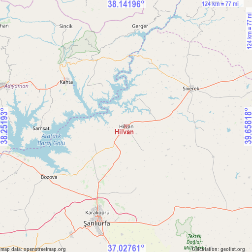
Hilvan GPS coordinates[2]
37° 35' 12.732" North, 38° 57' 18.18" East
| Map corner | latitude | longitude |
|---|---|---|
| Upper-left | 38.14196°, | 38.25193° |
| Center: | 37.58687°, | 38.95505° |
| Lower-right: | 37.02761°, | 39.65818° |
| Map W x H: | 123.9×123.9 km | = 77×77mi |
| max Lat: | 42.02683° ⇑72.4% North |
| Hilvan: | 37.58687° |
| min Lat: | ⇓27.6% South 35.9025° |
| min Long | Hilvan | max Long |
| 25.90902° | 38.95505° | 44.60099° |
| W 67.2%⇐ | ⇒32.8% E |
Elevation
Elevation of Hilvan is 590 m = 1936 ft, and this is 127.4 m = 418 ft below average elevation for this country.
| Max E: |
2682 m = 8799 ft | 54.8% |
| Avg. | 717.4 m = 2354 ft | |
| Hilvan | 590 m = 1936 ft | |
Min E: |
0 m = 0 ft | 45.2% |
See also: Turkey elevation on elevation.city.
Geographical zone
Hilvan is located in North temperate zone (between Tropic of Cancer and the Arctic Circle). Distance of this Northern Tropic circle is 1573.3 km =977.6 mi to South.| Distance of | km | miles | from Hilvan |
|---|---|---|---|
| North Pole | 5827.8 | 3621.2 | to North |
| Arctic Circle | 3221.9 | 2002 | to North |
| Tropic Cancer | 1573.3 | 977.6 | to South |
| Equator | 4179.3 | 2596.9 | to South |


Nearby cities:
15 places around Hilvan: (largest is in red/bold)
• Akziyaret
29.5 km =18.3 mi,  208°
208°
• Akıncılar
22.9 km =14.2 mi,  329°
329°
• Bucak
32.8 km =20.4 mi,  16°
16°
• Gerger
40.7 km =25.3 mi,  7°
7°
• Kabahaydar
23.7 km =14.7 mi,  151°
151°
• Kabahaydar
30.8 km =19.1 mi,  170°
170°
• Karaköprü
44.8 km =27.8 mi,  197°
197°
• Kâhta
36.6 km =22.7 mi,  307°
307°
• Narince
37.1 km =23.1 mi, 332°
• Ovacık
17.5 km =10.9 mi,  242°
242°
• Samsat
42.4 km =26.3 mi,  269°
269°
• Siverek
36.9 km =22.9 mi,  59°
59°
• Tilfetis
14.3 km =8.9 mi, 145°
• Çaylarbaşı
13.5 km =8.4 mi, 20°
• Şekerli
38.1 km =23.7 mi,  92°
92°
Sources, notices
• [Note1] Compared only with cities in Turkey existing in our database
• [Src1] Map data: © OpenStreetMap contributors (CC-BY-SA)
• [Src2] Other city data from geonames.org with taken over terms of usage.
• [Src3] Geographical zone / Annual Mean Temperature by Robert A. Rohde @ Wikipedia
