Kabahaydar geodata
Kabahaydar (Şanlıurfa) is a seat of a third-order administrative division; located in Turkey in Europe/Istanbul (GMT+3) time zone. In our database, there are 1323 cities with bigger population. Compared to other cities in Turkey, 77.4% of cities are located further ↑North; 68.5% of cities are located further ←West and 52.5% of cities have lower elevation than Kabahaydar. Note1


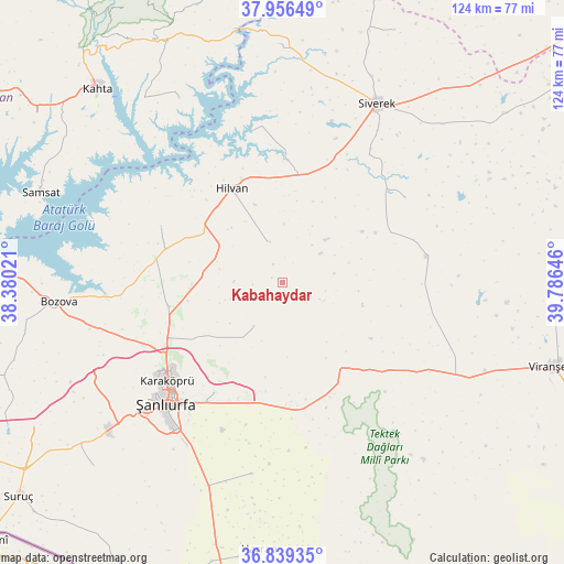
Kabahaydar GPS coordinates[2]
37° 24' 0" North, 39° 4' 59.988" East
| Map corner | latitude | longitude |
|---|---|---|
| Upper-left | 37.95649°, | 38.38021° |
| Center: | 37.4°, | 39.08333° |
| Lower-right: | 36.83935°, | 39.78646° |
| Map W x H: | 124.2×124.2 km | = 77.2×77.2mi |
| max Lat: | 42.02683° ⇑77.4% North |
| Kabahaydar: | 37.4° |
| min Lat: | ⇓22.6% South 35.9025° |
| min Long | Kabahaydar | max Long |
| 25.90902° | 39.08333° | 44.60099° |
| W 68.5%⇐ | ⇒31.5% E |
Elevation
Elevation of Kabahaydar is 750 m = 2461 ft, and this is 32.6 m = 107 ft above average elevation for this country.
| Max E: |
2682 m = 8799 ft | 47.5% |
| Kabahaydar | 750 m 2461 ft | |
| Avg. | 717.4 m = 2354 ft | |
Min E: |
0 m = 0 ft | 52.5% |
See also: Turkey elevation on elevation.city.
Geographical zone
Kabahaydar is located in North temperate zone (between Tropic of Cancer and the Arctic Circle). Distance of this Northern Tropic circle is 1552.6 km =964.7 mi to South.| Distance of | km | miles | from Kabahaydar |
|---|---|---|---|
| North Pole | 5848.6 | 3634.2 | to North |
| Arctic Circle | 3242.7 | 2014.9 | to North |
| Tropic Cancer | 1552.6 | 964.7 | to South |
| Equator | 4158.5 | 2584 | to South |


Nearby cities:
15 places around Kabahaydar: (largest is in red/bold)
• Akziyaret
25.9 km =16.1 mi,  258°
258°
• Akıncılar
46.6 km =29 mi,  330°
330°
• Hilvan
23.7 km =14.7 mi, 331°
• Kabahaydar
11.6 km =7.2 mi,  213°
213°
• Karakeçi
32.3 km =20.1 mi,  79°
79°
• Karaköprü
33.3 km =20.7 mi,  228°
228°
• Ovacık
29.6 km =18.4 mi,  295°
295°
• Siverek
44.5 km =27.7 mi,  27°
27°
• Tilfetis
9.6 km =6 mi,  340°
340°
• Yardımcı
42.7 km =26.5 mi,  189°
189°
• Yediyol
47.4 km =29.5 mi,  196°
196°
• Çamlıdere
27.3 km =17 mi,  183°
183°
• Çaylarbaşı
34 km =21.1 mi,  348°
348°
• Şanlıurfa
36.4 km =22.6 mi,  224°
224°
• Şekerli
32.8 km =20.4 mi,  54°
54°
Sources, notices
• [Note1] Compared only with cities in Turkey existing in our database
• [Src1] Map data: © OpenStreetMap contributors (CC-BY-SA)
• [Src2] Other city data from geonames.org with taken over terms of usage.
• [Src3] Geographical zone / Annual Mean Temperature by Robert A. Rohde @ Wikipedia
