Tilfetis geodata
Tilfetis (Şanlıurfa) is a seat of a third-order administrative division; located in Turkey in Europe/Istanbul (GMT+3) time zone. In our database, there are 1323 cities with bigger population. Compared to other cities in Turkey, 75.2% of cities are located further ↑North; 68.1% of cities are located further ←West and 50% of cities have lower elevation than Tilfetis. Note1


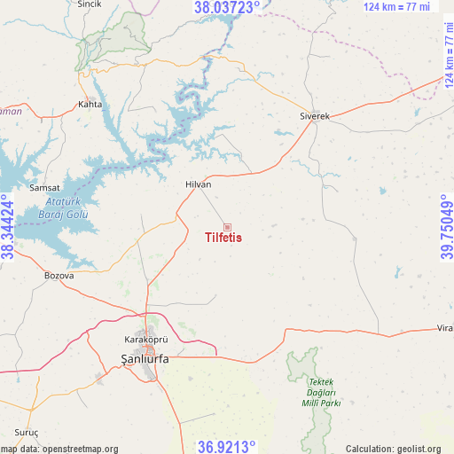
Tilfetis GPS coordinates[2]
37° 28' 52.86" North, 39° 2' 50.496" East
| Map corner | latitude | longitude |
|---|---|---|
| Upper-left | 38.03723°, | 38.34424° |
| Center: | 37.48135°, | 39.04736° |
| Lower-right: | 36.9213°, | 39.75049° |
| Map W x H: | 124.1×124.1 km | = 77.1×77.1mi |
| max Lat: | 42.02683° ⇑75.2% North |
| Tilfetis: | 37.48135° |
| min Lat: | ⇓24.8% South 35.9025° |
| min Long | Tilfetis | max Long |
| 25.90902° | 39.04736° | 44.60099° |
| W 68.1%⇐ | ⇒31.9% E |
Elevation
Elevation of Tilfetis is 692 m = 2270 ft, and this is 25.4 m = 83 ft below average elevation for this country.
| Max E: |
2682 m = 8799 ft | 50% |
| Avg. | 717.4 m = 2354 ft | |
| Tilfetis | 692 m = 2270 ft | |
Min E: |
0 m = 0 ft | 50% |
See also: Turkey elevation on elevation.city.
Geographical zone
Tilfetis is located in North temperate zone (between Tropic of Cancer and the Arctic Circle). Distance of this Northern Tropic circle is 1561.6 km =970.3 mi to South.| Distance of | km | miles | from Tilfetis |
|---|---|---|---|
| North Pole | 5839.5 | 3628.5 | to North |
| Arctic Circle | 3233.6 | 2009.3 | to North |
| Tropic Cancer | 1561.6 | 970.3 | to South |
| Equator | 4167.5 | 2589.6 | to South |


Nearby cities:
15 places around Tilfetis: (largest is in red/bold)
• Akziyaret
26.4 km =16.4 mi,  237°
237°
• Akıncılar
37.2 km =23.1 mi,  327°
327°
• Bozova
47.8 km =29.7 mi,  253°
253°
• Bucak
43.2 km =26.8 mi,  1°
1°
• Hilvan
14.3 km =8.9 mi, 325°
• Kabahaydar
9.6 km =6 mi,  160°
160°
• Kabahaydar
19 km =11.8 mi,  190°
190°
• Karakeçi
35.1 km =21.8 mi,  95°
95°
• Karaköprü
37.9 km =23.5 mi,  215°
215°
• Ovacık
23.9 km =14.9 mi,  278°
278°
• Siverek
38.6 km =24 mi,  37°
37°
• Çamlıdere
36.4 km =22.6 mi,  177°
177°
• Çaylarbaşı
24.5 km =15.2 mi,  352°
352°
• Şanlıurfa
41.5 km =25.8 mi,  212°
212°
• Şekerli
31.6 km =19.6 mi,  71°
71°
Sources, notices
• [Note1] Compared only with cities in Turkey existing in our database
• [Src1] Map data: © OpenStreetMap contributors (CC-BY-SA)
• [Src2] Other city data from geonames.org with taken over terms of usage.
• [Src3] Geographical zone / Annual Mean Temperature by Robert A. Rohde @ Wikipedia
