Suşehri geodata
Suşehri (Sivas) is a seat of a second-order administrative division; located in Turkey in Europe/Istanbul (GMT+3) time zone. With population of 25,820 people, there are 279 cities with bigger population in this country. Compared to other cities in Turkey, 71.7% of cities are located further ↓South; 62.1% of cities are located further ←West and 71.5% of cities have lower elevation than Suşehri. Note1


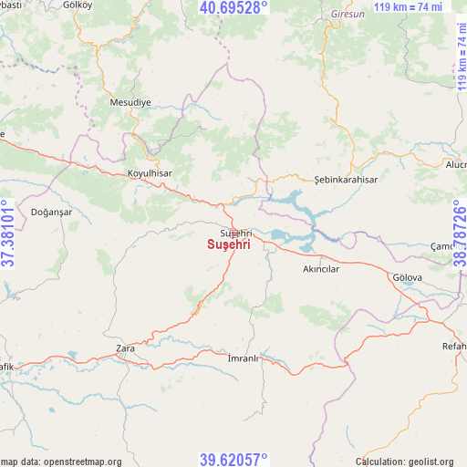
Suşehri GPS coordinates[2]
40° 9' 36.18" North, 38° 5' 2.868" East
| Map corner | latitude | longitude |
|---|---|---|
| Upper-left | 40.69528°, | 37.38101° |
| Center: | 40.16005°, | 38.08413° |
| Lower-right: | 39.62057°, | 38.78726° |
| Map W x H: | 119.5×119.5 km | = 74.3×74.3mi |
| max Lat: | 42.02683° ⇑28.3% North |
| Suşehri: | 40.16005° |
| min Lat: | ⇓71.7% South 35.9025° |
| min Long | Suşehri | max Long |
| 25.90902° | 38.08413° | 44.60099° |
| W 62.1%⇐ | ⇒37.9% E |
Elevation
Elevation of Suşehri is 1049 m = 3442 ft, and this is 331.6 m = 1088 ft above average elevation for this country.
| Max E: |
2682 m = 8799 ft | 28.5% |
| Suşehri | 1049 m 3442 ft | |
| Avg. | 717.4 m = 2354 ft | |
Min E: |
0 m = 0 ft | 71.5% |
See also: Turkey elevation on elevation.city.
Geographical zone
Suşehri is located in North temperate zone (between Tropic of Cancer and the Arctic Circle). Distance of this Northern Tropic circle is 1859.5 km =1155.4 mi to South.| Distance of | km | miles | from Suşehri |
|---|---|---|---|
| North Pole | 5541.7 | 3443.5 | to North |
| Arctic Circle | 2935.8 | 1824.2 | to North |
| Tropic Cancer | 1859.5 | 1155.4 | to South |
| Equator | 4465.4 | 2774.7 | to South |


Nearby cities:
15 places around Suşehri: (largest is in red/bold)
• Akarsu
51.9 km =32.2 mi,  119°
119°
• Aksu
8.9 km =5.5 mi,  208°
208°
• Akıncılar
24.1 km =15 mi,  114°
114°
• Doğanşar
47.3 km =29.4 mi,  276°
276°
• Gökçekent
14.3 km =8.9 mi,  11°
11°
• Gölova
45.8 km =28.5 mi,  103°
103°
• Karacaören
47.8 km =29.7 mi,  176°
176°
• Koyulhisar
27.2 km =16.9 mi,  305°
305°
• Mesudiye
42 km =26.1 mi,  321°
321°
• Ortakent
26.7 km =16.6 mi,  346°
346°
• Yeşilce
48.4 km =30.1 mi,  329°
329°
• Zara
40.2 km =25 mi,  223°
223°
• İmranlı
31.7 km =19.7 mi, 175°
• Şebin Karahisar
32.2 km =20 mi,  63°
63°
• Şerefiye
28.4 km =17.6 mi,  259°
259°
Sources, notices
• [Note1] Compared only with cities in Turkey existing in our database
• [Src1] Map data: © OpenStreetMap contributors (CC-BY-SA)
• [Src2] Other city data from geonames.org with taken over terms of usage.
• [Src3] Geographical zone / Annual Mean Temperature by Robert A. Rohde @ Wikipedia
