Gökçekent geodata
Gökçekent (Sivas) is a seat of a third-order administrative division; located in Turkey in Europe/Istanbul (GMT+3) time zone. In our database, there are 1323 cities with bigger population. Compared to other cities in Turkey, 74.2% of cities are located further ↓South; 62.4% of cities are located further ←West and 86.6% of cities have lower elevation than Gökçekent. Note1


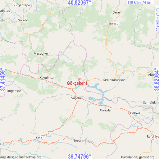
Gökçekent GPS coordinates[2]
40° 17' 11.184" North, 38° 7' 3.756" East
| Map corner | latitude | longitude |
|---|---|---|
| Upper-left | 40.82067°, | 37.41459° |
| Center: | 40.28644°, | 38.11771° |
| Lower-right: | 39.74796°, | 38.82084° |
| Map W x H: | 119.3×119.3 km | = 74.1×74.1mi |
| max Lat: | 42.02683° ⇑25.8% North |
| Gökçekent: | 40.28644° |
| min Lat: | ⇓74.2% South 35.9025° |
| min Long | Gökçekent | max Long |
| 25.90902° | 38.11771° | 44.60099° |
| W 62.4%⇐ | ⇒37.6% E |
Elevation
Elevation of Gökçekent is 1357 m = 4452 ft, and this is 639.6 m = 2098 ft above average elevation for this country.
| Max E: |
2682 m = 8799 ft | 13.4% |
| Gökçekent | 1357 m 4452 ft | |
| Avg. | 717.4 m = 2354 ft | |
Min E: |
0 m = 0 ft | 86.6% |
See also: Turkey elevation on elevation.city.
Geographical zone
Gökçekent is located in North temperate zone (between Tropic of Cancer and the Arctic Circle). Distance of this Northern Tropic circle is 1873.5 km =1164.1 mi to South.| Distance of | km | miles | from Gökçekent |
|---|---|---|---|
| North Pole | 5527.6 | 3434.7 | to North |
| Arctic Circle | 2921.7 | 1815.5 | to North |
| Tropic Cancer | 1873.5 | 1164.1 | to South |
| Equator | 4479.4 | 2783.4 | to South |


Nearby cities:
15 places around Gökçekent: (largest is in red/bold)
• Aksu
23 km =14.3 mi,  197°
197°
• Akıncılar
30.6 km =19 mi,  141°
141°
• Doğanşar
50.5 km =31.4 mi,  260°
260°
• Gölova
48.5 km =30.1 mi,  121°
121°
• Kovanlık
52.1 km =32.4 mi,  359°
359°
• Koyulhisar
25 km =15.5 mi,  273°
273°
• Mesudiye
34.6 km =21.5 mi,  302°
302°
• Ortakent
15 km =9.3 mi,  322°
322°
• Suşehri
14.3 km =8.9 mi,  191°
191°
• Topçam
47 km =29.2 mi, 321°
• Yavuzkemal
48.9 km =30.4 mi,  22°
22°
• Yeşilce
38.9 km =24.2 mi, 315°
• İmranlı
45.7 km =28.4 mi,  180°
180°
• Şebin Karahisar
25.9 km =16.1 mi,  89°
89°
• Şerefiye
36.3 km =22.6 mi,  237°
237°
Sources, notices
• [Note1] Compared only with cities in Turkey existing in our database
• [Src1] Map data: © OpenStreetMap contributors (CC-BY-SA)
• [Src2] Other city data from geonames.org with taken over terms of usage.
• [Src3] Geographical zone / Annual Mean Temperature by Robert A. Rohde @ Wikipedia
