Gücük geodata
Gücük (Kahramanmaraş) is a seat of a third-order administrative division; located in Turkey in Europe/Istanbul (GMT+3) time zone. In our database, there are 1323 cities with bigger population. Compared to other cities in Turkey, 58.2% of cities are located further ↑North; 58.6% of cities are located further ←West and 89.8% of cities have lower elevation than Gücük. Note1


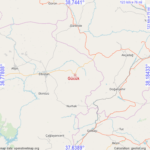
Gücük GPS coordinates[2]
38° 11' 36.96" North, 37° 28' 52.32" East
| Map corner | latitude | longitude |
|---|---|---|
| Upper-left | 38.7441°, | 36.77808° |
| Center: | 38.1936°, | 37.4812° |
| Lower-right: | 37.6389°, | 38.18433° |
| Map W x H: | 122.9×122.9 km | = 76.4×76.4mi |
| max Lat: | 42.02683° ⇑58.2% North |
| Gücük: | 38.1936° |
| min Lat: | ⇓41.8% South 35.9025° |
| min Long | Gücük | max Long |
| 25.90902° | 37.4812° | 44.60099° |
| W 58.6%⇐ | ⇒41.4% E |
Elevation
Elevation of Gücük is 1474 m = 4836 ft, and this is 756.6 m = 2482 ft above average elevation for this country.
| Max E: |
2682 m = 8799 ft | 10.2% |
| Gücük | 1474 m 4836 ft | |
| Avg. | 717.4 m = 2354 ft | |
Min E: |
0 m = 0 ft | 89.8% |
See also: Turkey elevation on elevation.city.
Geographical zone
Gücük is located in North temperate zone (between Tropic of Cancer and the Arctic Circle). Distance of this Northern Tropic circle is 1640.8 km =1019.5 mi to South.| Distance of | km | miles | from Gücük |
|---|---|---|---|
| North Pole | 5760.3 | 3579.3 | to North |
| Arctic Circle | 3154.4 | 1960.1 | to North |
| Tropic Cancer | 1640.8 | 1019.5 | to South |
| Equator | 4246.7 | 2638.8 | to South |


Nearby cities:
15 places around Gücük: (largest is in red/bold)
• Afşin
49.9 km =31 mi,  276°
276°
• Akçadağ
45.6 km =28.3 mi,  69°
69°
• Balaban
30.9 km =19.2 mi,  15°
15°
• Celeyke
29.7 km =18.5 mi,  239°
239°
• Darende
39.2 km =24.4 mi,  3°
3°
• Doğanşehir
36.1 km =22.4 mi,  109°
109°
• Elbistan
24.8 km =15.4 mi,  273°
273°
• Gölbaşı
47.6 km =29.6 mi,  163°
163°
• Harmanlı
45.8 km =28.5 mi,  149°
149°
• Kürecik
27.7 km =17.2 mi,  54°
54°
• Levent
42.3 km =26.3 mi, 50°
• Nurhak
25.8 km =16 mi,  187°
187°
• Sürgü
47.1 km =29.3 mi,  116°
116°
• Tanır
55.6 km =34.5 mi,  296°
296°
• Çağlayancerit
52.7 km =32.7 mi,  198°
198°
Sources, notices
• [Note1] Compared only with cities in Turkey existing in our database
• [Src1] Map data: © OpenStreetMap contributors (CC-BY-SA)
• [Src2] Other city data from geonames.org with taken over terms of usage.
• [Src3] Geographical zone / Annual Mean Temperature by Robert A. Rohde @ Wikipedia
