Han geodata
Han (Eskişehir) is a seat of a second-order administrative division; located in Turkey in Europe/Istanbul (GMT+3) time zone. In our database, there are 1323 cities with bigger population. Compared to other cities in Turkey, 56.8% of cities are located further ↓South; 71.1% of cities are located further →East and 81.3% of cities have lower elevation than Han. Note1


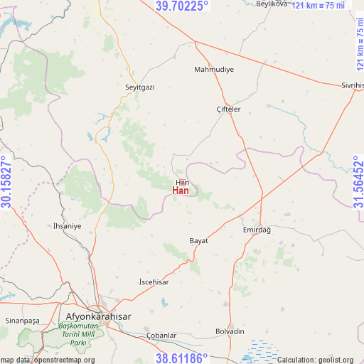
Han GPS coordinates[2]
39° 9' 33.012" North, 30° 51' 41.004" East
| Map corner | latitude | longitude |
|---|---|---|
| Upper-left | 39.70225°, | 30.15827° |
| Center: | 39.15917°, | 30.86139° |
| Lower-right: | 38.61186°, | 31.56452° |
| Map W x H: | 121.2×121.2 km | = 75.3×75.3mi |
| max Lat: | 42.02683° ⇑43.2% North |
| Han: | 39.15917° |
| min Lat: | ⇓56.8% South 35.9025° |
| min Long | Han | max Long |
| 25.90902° | 30.86139° | 44.60099° |
| W 28.9%⇐ | ⇒71.1% E |
Elevation
Elevation of Han is 1220 m = 4003 ft, and this is 502.6 m = 1649 ft above average elevation for this country.
| Max E: |
2682 m = 8799 ft | 18.7% |
| Han | 1220 m 4003 ft | |
| Avg. | 717.4 m = 2354 ft | |
Min E: |
0 m = 0 ft | 81.3% |
See also: Turkey elevation on elevation.city.
Geographical zone
Han is located in North temperate zone (between Tropic of Cancer and the Arctic Circle). Distance of this Northern Tropic circle is 1748.2 km =1086.3 mi to South.| Distance of | km | miles | from Han |
|---|---|---|---|
| North Pole | 5653 | 3512.6 | to North |
| Arctic Circle | 3047.1 | 1893.4 | to North |
| Tropic Cancer | 1748.2 | 1086.3 | to South |
| Equator | 4354.1 | 2705.5 | to South |


Nearby cities:
15 places around Han: (largest is in red/bold)
• Afyonkarahisar
52.5 km =32.6 mi,  211°
211°
• Bayat
20.3 km =12.6 mi,  164°
164°
• Bolvadin
52.4 km =32.6 mi, 161°
• Davulga
48.4 km =30.1 mi,  114°
114°
• Emirdağ
29.3 km =18.2 mi,  121°
121°
• Işıklar
55.3 km =34.4 mi,  190°
190°
• Kaymaz
48.3 km =30 mi,  34°
34°
• Kırka
31.8 km =19.8 mi,  294°
294°
• Mahmudiye
39.2 km =24.4 mi,  16°
16°
• Seyitgazi
34.8 km =21.6 mi,  335°
335°
• Umraniye
32.2 km =20 mi,  86°
86°
• Çifteler
29.2 km =18.1 mi, 31°
• Çobanlar
51.4 km =31.9 mi, 187°
• İhsaniye
41 km =25.5 mi,  249°
249°
• İscehisar
34.4 km =21.4 mi,  196°
196°
Sources, notices
• [Note1] Compared only with cities in Turkey existing in our database
• [Src1] Map data: © OpenStreetMap contributors (CC-BY-SA)
• [Src2] Other city data from geonames.org with taken over terms of usage.
• [Src3] Geographical zone / Annual Mean Temperature by Robert A. Rohde @ Wikipedia
