Umraniye geodata
Umraniye (Afyonkarahisar) is a seat of a third-order administrative division; located in Turkey in Europe/Istanbul (GMT+3) time zone. In our database, there are 1323 cities with bigger population. Compared to other cities in Turkey, 57.1% of cities are located further ↓South; 69.5% of cities are located further →East and 61.5% of cities have lower elevation than Umraniye. Note1


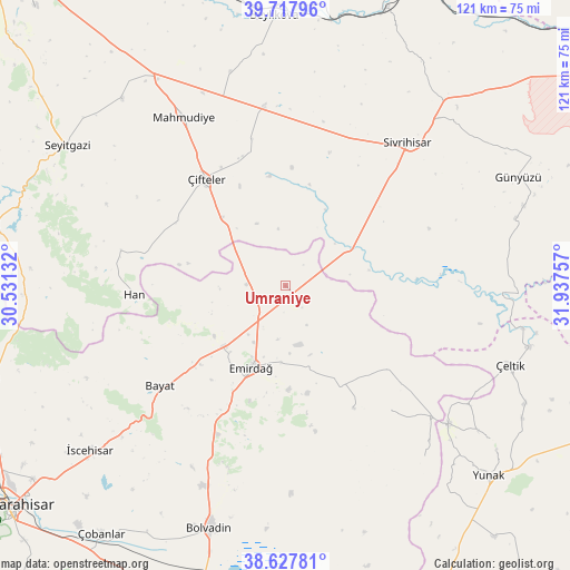
Umraniye GPS coordinates[2]
39° 10' 30" North, 31° 14' 3.984" East
| Map corner | latitude | longitude |
|---|---|---|
| Upper-left | 39.71796°, | 30.53132° |
| Center: | 39.175°, | 31.23444° |
| Lower-right: | 38.62781°, | 31.93757° |
| Map W x H: | 121.2×121.2 km | = 75.3×75.3mi |
| max Lat: | 42.02683° ⇑42.9% North |
| Umraniye: | 39.175° |
| min Lat: | ⇓57.1% South 35.9025° |
| min Long | Umraniye | max Long |
| 25.90902° | 31.23444° | 44.60099° |
| W 30.5%⇐ | ⇒69.5% E |
Elevation
Elevation of Umraniye is 905 m = 2969 ft, and this is 187.6 m = 615 ft above average elevation for this country.
| Max E: |
2682 m = 8799 ft | 38.5% |
| Umraniye | 905 m 2969 ft | |
| Avg. | 717.4 m = 2354 ft | |
Min E: |
0 m = 0 ft | 61.5% |
See also: Turkey elevation on elevation.city.
Geographical zone
Umraniye is located in North temperate zone (between Tropic of Cancer and the Arctic Circle). Distance of this Northern Tropic circle is 1749.9 km =1087.3 mi to South.| Distance of | km | miles | from Umraniye |
|---|---|---|---|
| North Pole | 5651.2 | 3511.5 | to North |
| Arctic Circle | 3045.3 | 1892.3 | to North |
| Tropic Cancer | 1749.9 | 1087.3 | to South |
| Equator | 4355.9 | 2706.6 | to South |


Nearby cities:
15 places around Umraniye: (largest is in red/bold)
• Bayat
34.2 km =21.3 mi,  231°
231°
• Beylikova
57 km =35.4 mi,  357°
357°
• Bolvadin
54 km =33.6 mi,  197°
197°
• Davulga
24.8 km =15.4 mi,  151°
151°
• Emirdağ
18.7 km =11.6 mi, 202°
• Günyüzü
54.7 km =34 mi,  64°
64°
• Han
32.2 km =20 mi,  266°
266°
• Kaymaz
38.3 km =23.8 mi,  352°
352°
• Mahmudiye
41.7 km =25.9 mi,  329°
329°
• Seyitgazi
55.3 km =34.4 mi,  302°
302°
• Sivrihisar
40 km =24.9 mi,  40°
40°
• Yunak
58.8 km =36.5 mi,  133°
133°
• Çeltik
50.8 km =31.6 mi,  109°
109°
• Çifteler
28.6 km =17.8 mi,  324°
324°
• İscehisar
54.4 km =33.8 mi, 230°
Sources, notices
• [Note1] Compared only with cities in Turkey existing in our database
• [Src1] Map data: © OpenStreetMap contributors (CC-BY-SA)
• [Src2] Other city data from geonames.org with taken over terms of usage.
• [Src3] Geographical zone / Annual Mean Temperature by Robert A. Rohde @ Wikipedia
