Çobanlar geodata
Çobanlar (Afyonkarahisar) is a seat of a second-order administrative division; located in Turkey in Europe/Istanbul (GMT+3) time zone. In our database, there are 1323 cities with bigger population. Compared to other cities in Turkey, 50.1% of cities are located further ↓South; 71.5% of cities are located further →East and 67.4% of cities have lower elevation than Çobanlar. Note1


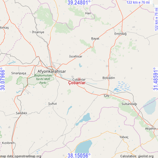
Çobanlar GPS coordinates[2]
38° 42' 5.004" North, 30° 46' 58.008" East
| Map corner | latitude | longitude |
|---|---|---|
| Upper-left | 39.24801°, | 30.07966° |
| Center: | 38.70139°, | 30.78278° |
| Lower-right: | 38.15056°, | 31.48591° |
| Map W x H: | 122×122 km | = 75.8×75.8mi |
| max Lat: | 42.02683° ⇑49.9% North |
| Çobanlar: | 38.70139° |
| min Lat: | ⇓50.1% South 35.9025° |
| min Long | Çobanlar | max Long |
| 25.90902° | 30.78278° | 44.60099° |
| W 28.5%⇐ | ⇒71.5% E |
Elevation
Elevation of Çobanlar is 992 m = 3255 ft, and this is 274.6 m = 901 ft above average elevation for this country.
| Max E: |
2682 m = 8799 ft | 32.6% |
| Çobanlar | 992 m 3255 ft | |
| Avg. | 717.4 m = 2354 ft | |
Min E: |
0 m = 0 ft | 67.4% |
See also: Turkey elevation on elevation.city.
Geographical zone
Çobanlar is located in North temperate zone (between Tropic of Cancer and the Arctic Circle). Distance of this Northern Tropic circle is 1697.3 km =1054.7 mi to South.| Distance of | km | miles | from Çobanlar |
|---|---|---|---|
| North Pole | 5703.9 | 3544.2 | to North |
| Arctic Circle | 3098 | 1925 | to North |
| Tropic Cancer | 1697.3 | 1054.7 | to South |
| Equator | 4303.2 | 2673.9 | to South |


Nearby cities:
15 places around Çobanlar: (largest is in red/bold)
• Afyonkarahisar
21.7 km =13.5 mi,  286°
286°
• Bayat
33.6 km =20.9 mi,  21°
21°
• Bolvadin
23.1 km =14.4 mi,  87°
87°
• Emirdağ
47.6 km =29.6 mi,  41°
41°
• Han
51.4 km =31.9 mi,  7°
7°
• Işıklar
5 km =3.1 mi,  227°
227°
• Karadirek
54.1 km =33.6 mi,  254°
254°
• Kumdanlı
45.2 km =28.1 mi,  158°
158°
• Sandıklı
51.8 km =32.2 mi,  239°
239°
• Sinanpaşa
47.1 km =29.3 mi,  275°
275°
• Sultandağı
43.1 km =26.8 mi,  116°
116°
• Çay
24.6 km =15.3 mi, 119°
• İhsaniye
48.3 km =30 mi,  318°
318°
• İscehisar
18.1 km =11.2 mi,  351°
351°
• Şuhut
28 km =17.4 mi, 227°
Sources, notices
• [Note1] Compared only with cities in Turkey existing in our database
• [Src1] Map data: © OpenStreetMap contributors (CC-BY-SA)
• [Src2] Other city data from geonames.org with taken over terms of usage.
• [Src3] Geographical zone / Annual Mean Temperature by Robert A. Rohde @ Wikipedia
