Mahmudiye geodata
Mahmudiye (Eskişehir) is a seat of a second-order administrative division; located in Turkey in Europe/Istanbul (GMT+3) time zone. In our database, there are 1323 cities with bigger population. Compared to other cities in Turkey, 61.3% of cities are located further ↓South; 70.6% of cities are located further →East and 60.2% of cities have lower elevation than Mahmudiye. Note1


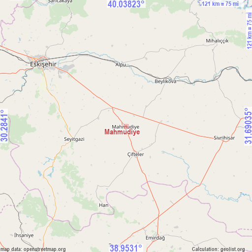
Mahmudiye GPS coordinates[2]
39° 29' 52.008" North, 30° 59' 13.992" East
| Map corner | latitude | longitude |
|---|---|---|
| Upper-left | 40.03823°, | 30.2841° |
| Center: | 39.49778°, | 30.98722° |
| Lower-right: | 38.9531°, | 31.69035° |
| Map W x H: | 120.7×120.7 km | = 75×75mi |
| max Lat: | 42.02683° ⇑38.7% North |
| Mahmudiye: | 39.49778° |
| min Lat: | ⇓61.3% South 35.9025° |
| min Long | Mahmudiye | max Long |
| 25.90902° | 30.98722° | 44.60099° |
| W 29.4%⇐ | ⇒70.6% E |
Elevation
Elevation of Mahmudiye is 887 m = 2910 ft, and this is 169.6 m = 556 ft above average elevation for this country.
| Max E: |
2682 m = 8799 ft | 39.8% |
| Mahmudiye | 887 m 2910 ft | |
| Avg. | 717.4 m = 2354 ft | |
Min E: |
0 m = 0 ft | 60.2% |
See also: Turkey elevation on elevation.city.
Geographical zone
Mahmudiye is located in North temperate zone (between Tropic of Cancer and the Arctic Circle). Distance of this Northern Tropic circle is 1785.8 km =1109.6 mi to South.| Distance of | km | miles | from Mahmudiye |
|---|---|---|---|
| North Pole | 5615.3 | 3489.2 | to North |
| Arctic Circle | 3009.4 | 1870 | to North |
| Tropic Cancer | 1785.8 | 1109.6 | to South |
| Equator | 4391.7 | 2728.9 | to South |


Nearby cities:
15 places around Mahmudiye: (largest is in red/bold)
• Alpu
30.2 km =18.8 mi,  355°
355°
• Beylikova
28.1 km =17.5 mi,  41°
41°
• Bozan
33.7 km =20.9 mi,  16°
16°
• Emirdağ
55 km =34.2 mi,  165°
165°
• Eskişehir
50.6 km =31.4 mi,  307°
307°
• Han
39.2 km =24.4 mi,  196°
196°
• Kaymaz
16.6 km =10.3 mi,  82°
82°
• Kırka
46.5 km =28.9 mi,  238°
238°
• Odunpazarı
49 km =30.4 mi, 307°
• Sevinç
40.5 km =25.2 mi,  320°
320°
• Seyitgazi
25.8 km =16 mi,  256°
256°
• Sivrihisar
47.2 km =29.3 mi,  96°
96°
• Tepebaşı
52.7 km =32.7 mi, 311°
• Umraniye
41.7 km =25.9 mi,  149°
149°
• Çifteler
13.5 km =8.4 mi,  160°
160°
Sources, notices
• [Note1] Compared only with cities in Turkey existing in our database
• [Src1] Map data: © OpenStreetMap contributors (CC-BY-SA)
• [Src2] Other city data from geonames.org with taken over terms of usage.
• [Src3] Geographical zone / Annual Mean Temperature by Robert A. Rohde @ Wikipedia
