Işıklar geodata
Işıklar (Afyonkarahisar) is a populated place; located in Turkey in Europe/Istanbul (GMT+3) time zone. With population of 7,250 people, there are 607 cities with bigger population in this country. Compared to other cities in Turkey, 50.4% of cities are located further ↑North; 71.7% of cities are located further →East and 68.8% of cities have lower elevation than Işıklar. Note1


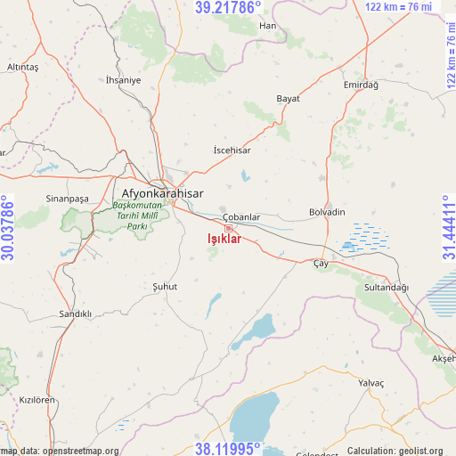
Işıklar GPS coordinates[2]
38° 40' 15.636" North, 30° 44' 27.528" East
| Map corner | latitude | longitude |
|---|---|---|
| Upper-left | 39.21786°, | 30.03786° |
| Center: | 38.67101°, | 30.74098° |
| Lower-right: | 38.11995°, | 31.44411° |
| Map W x H: | 122.1×122.1 km | = 75.9×75.9mi |
| max Lat: | 42.02683° ⇑50.4% North |
| Işıklar: | 38.67101° |
| min Lat: | ⇓49.6% South 35.9025° |
| min Long | Işıklar | max Long |
| 25.90902° | 30.74098° | 44.60099° |
| W 28.3%⇐ | ⇒71.7% E |
Elevation
Elevation of Işıklar is 1012 m = 3320 ft, and this is 294.6 m = 967 ft above average elevation for this country.
| Max E: |
2682 m = 8799 ft | 31.2% |
| Işıklar | 1012 m 3320 ft | |
| Avg. | 717.4 m = 2354 ft | |
Min E: |
0 m = 0 ft | 68.8% |
See also: Turkey elevation on elevation.city.
Geographical zone
Işıklar is located in North temperate zone (between Tropic of Cancer and the Arctic Circle). Distance of this Northern Tropic circle is 1693.9 km =1052.5 mi to South.| Distance of | km | miles | from Işıklar |
|---|---|---|---|
| North Pole | 5707.2 | 3546.3 | to North |
| Arctic Circle | 3101.4 | 1927.1 | to North |
| Tropic Cancer | 1693.9 | 1052.5 | to South |
| Equator | 4299.8 | 2671.8 | to South |


Nearby cities:
15 places around Işıklar: (largest is in red/bold)
• Afyonkarahisar
19.6 km =12.2 mi,  299°
299°
• Bayat
38.2 km =23.7 mi,  24°
24°
• Bolvadin
27.1 km =16.8 mi,  80°
80°
• Emirdağ
52.5 km =32.6 mi,  42°
42°
• Haydarlı
55.2 km =34.3 mi,  214°
214°
• Karadirek
49.7 km =30.9 mi,  256°
256°
• Kumdanlı
43.7 km =27.2 mi,  152°
152°
• Sandıklı
47 km =29.2 mi,  240°
240°
• Sinanpaşa
44 km =27.3 mi,  280°
280°
• Sultandağı
45.1 km =28 mi,  110°
110°
• Çay
26.5 km =16.5 mi, 109°
• Çobanlar
5 km =3.1 mi,  47°
47°
• İhsaniye
48.7 km =30.3 mi,  324°
324°
• İscehisar
21.2 km =13.2 mi,  2°
2°
• Şuhut
23 km =14.3 mi,  227°
227°
Sources, notices
• [Note1] Compared only with cities in Turkey existing in our database
• [Src1] Map data: © OpenStreetMap contributors (CC-BY-SA)
• [Src2] Other city data from geonames.org with taken over terms of usage.
• [Src3] Geographical zone / Annual Mean Temperature by Robert A. Rohde @ Wikipedia
