Emirdağ geodata
Emirdağ (Afyonkarahisar) is a seat of a second-order administrative division; located in Turkey in Europe/Istanbul (GMT+3) time zone. With population of 20,063 people, there are 330 cities with bigger population in this country. Compared to other cities in Turkey, 54.8% of cities are located further ↓South; 70% of cities are located further →East and 65.4% of cities have lower elevation than Emirdağ. Note1


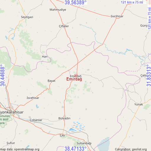
Emirdağ GPS coordinates[2]
39° 1' 10.992" North, 31° 9' 0" East
| Map corner | latitude | longitude |
|---|---|---|
| Upper-left | 39.56389°, | 30.44688° |
| Center: | 39.01972°, | 31.15° |
| Lower-right: | 38.47133°, | 31.85313° |
| Map W x H: | 121.5×121.5 km | = 75.5×75.5mi |
| max Lat: | 42.02683° ⇑45.2% North |
| Emirdağ: | 39.01972° |
| min Lat: | ⇓54.8% South 35.9025° |
| min Long | Emirdağ | max Long |
| 25.90902° | 31.15° | 44.60099° |
| W 30%⇐ | ⇒70% E |
Elevation
Elevation of Emirdağ is 964 m = 3163 ft, and this is 246.6 m = 809 ft above average elevation for this country.
| Max E: |
2682 m = 8799 ft | 34.6% |
| Emirdağ | 964 m 3163 ft | |
| Avg. | 717.4 m = 2354 ft | |
Min E: |
0 m = 0 ft | 65.4% |
See also: Turkey elevation on elevation.city.
Geographical zone
Emirdağ is located in North temperate zone (between Tropic of Cancer and the Arctic Circle). Distance of this Northern Tropic circle is 1732.7 km =1076.6 mi to South.| Distance of | km | miles | from Emirdağ |
|---|---|---|---|
| North Pole | 5668.5 | 3522.2 | to North |
| Arctic Circle | 3062.6 | 1903 | to North |
| Tropic Cancer | 1732.7 | 1076.6 | to South |
| Equator | 4338.6 | 2695.9 | to South |


Nearby cities:
15 places around Emirdağ: (largest is in red/bold)
• Bayat
19.9 km =12.4 mi,  258°
258°
• Bolvadin
35.4 km =22 mi,  194°
194°
• Davulga
19.7 km =12.2 mi,  103°
103°
• Han
29.3 km =18.2 mi,  301°
301°
• Işıklar
52.5 km =32.6 mi,  222°
222°
• Kaymaz
55.3 km =34.4 mi,  2°
2°
• Mahmudiye
55 km =34.2 mi,  345°
345°
• Sultandağı
54.7 km =34 mi,  172°
172°
• Umraniye
18.7 km =11.6 mi,  22°
22°
• Yunak
55.3 km =34.4 mi,  114°
114°
• Çay
48.7 km =30.3 mi, 192°
• Çeltik
55.3 km =34.4 mi,  89°
89°
• Çifteler
41.5 km =25.8 mi, 346°
• Çobanlar
47.6 km =29.6 mi, 221°
• İscehisar
38.8 km =24.1 mi,  243°
243°
Sources, notices
• [Note1] Compared only with cities in Turkey existing in our database
• [Src1] Map data: © OpenStreetMap contributors (CC-BY-SA)
• [Src2] Other city data from geonames.org with taken over terms of usage.
• [Src3] Geographical zone / Annual Mean Temperature by Robert A. Rohde @ Wikipedia
