Afyonkarahisar geodata
Afyonkarahisar is a seat of a first-order administrative division; located in Turkey in Europe/Istanbul (GMT+3) time zone. With population of 146,136 people, there are 65 cities with bigger population in this country. Compared to other cities in Turkey, 51.3% of cities are located further ↓South; 72.7% of cities are located further →East and 69.4% of cities have lower elevation than Afyonkarahisar. Note1


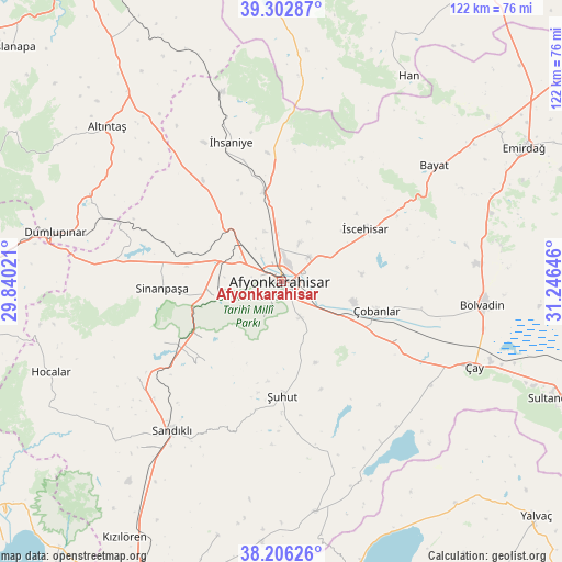
Afyonkarahisar GPS coordinates[2]
38° 45' 24.012" North, 30° 32' 35.988" East
| Map corner | latitude | longitude |
|---|---|---|
| Upper-left | 39.30287°, | 29.84021° |
| Center: | 38.75667°, | 30.54333° |
| Lower-right: | 38.20626°, | 31.24646° |
| Map W x H: | 121.9×121.9 km | = 75.7×75.7mi |
| max Lat: | 42.02683° ⇑48.7% North |
| Afyonkarahisar: | 38.75667° |
| min Lat: | ⇓51.3% South 35.9025° |
| min Long | Afyonkarahisar | max Long |
| 25.90902° | 30.54333° | 44.60099° |
| W 27.3%⇐ | ⇒72.7% E |
Elevation
Elevation of Afyonkarahisar is 1019 m = 3343 ft, and this is 301.6 m = 990 ft above average elevation for this country.
| Max E: |
2682 m = 8799 ft | 30.6% |
| Afyonkarahisar | 1019 m 3343 ft | |
| Avg. | 717.4 m = 2354 ft | |
Min E: |
0 m = 0 ft | 69.4% |
See also: Afyonkarahisar elevation on elevation.city.
Geographical zone
Afyonkarahisar is located in North temperate zone (between Tropic of Cancer and the Arctic Circle). Distance of this Northern Tropic circle is 1703.4 km =1058.4 mi to South.| Distance of | km | miles | from Afyonkarahisar |
|---|---|---|---|
| North Pole | 5697.7 | 3540.4 | to North |
| Arctic Circle | 3091.8 | 1921.2 | to North |
| Tropic Cancer | 1703.4 | 1058.4 | to South |
| Equator | 4309.3 | 2677.7 | to South |


Nearby cities:
15 places around Afyonkarahisar: (largest is in red/bold)
• Altıntaş
50.5 km =31.4 mi,  311°
311°
• Bayat
41.5 km =25.8 mi,  52°
52°
• Bolvadin
44.1 km =27.4 mi,  96°
96°
• Dumlupınar
50.2 km =31.2 mi,  282°
282°
• Han
52.5 km =32.6 mi,  31°
31°
• Hocalar
53.8 km =33.4 mi,  248°
248°
• Işıklar
19.6 km =12.2 mi,  119°
119°
• Karadirek
37.6 km =23.4 mi,  236°
236°
• Sandıklı
40.2 km =25 mi,  216°
216°
• Sinanpaşa
26.1 km =16.2 mi,  267°
267°
• Çay
45.9 km =28.5 mi,  113°
113°
• Çobanlar
21.7 km =13.5 mi, 106°
• İhsaniye
32.2 km =20 mi,  340°
340°
• İscehisar
21.4 km =13.3 mi,  56°
56°
• Şuhut
25.1 km =15.6 mi,  179°
179°
In other languages:
- In German: Afyon, Afyonkarahisar
- In Russian: Афьонкарахисар, Афьон-Карахисар
- In Chinese: 阿菲永卡拉希萨尔
Sources, notices
• [Note1] Compared only with cities in Turkey existing in our database
• [Src1] Map data: © OpenStreetMap contributors (CC-BY-SA)
• [Src2] Other city data from geonames.org with taken over terms of usage.
• [Src3] Geographical zone / Annual Mean Temperature by Robert A. Rohde @ Wikipedia
