Ağrı geodata
Ağrı is a seat of a first-order administrative division; located in Turkey in Europe/Istanbul (GMT+3) time zone. With population of 92,022 people, there are 93 cities with bigger population in this country. Compared to other cities in Turkey, 64.5% of cities are located further ↓South; 96.8% of cities are located further ←West and 94.1% of cities have lower elevation than Ağrı. Note1


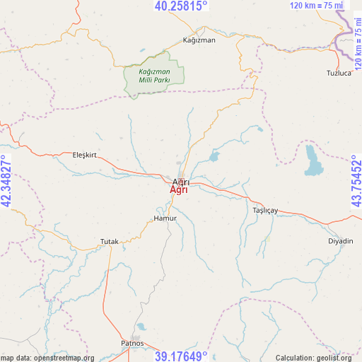
Ağrı GPS coordinates[2]
39° 43' 9.984" North, 43° 3' 5.004" East
| Map corner | latitude | longitude |
|---|---|---|
| Upper-left | 40.25815°, | 42.34827° |
| Center: | 39.71944°, | 43.05139° |
| Lower-right: | 39.17649°, | 43.75452° |
| Map W x H: | 120.3×120.3 km | = 74.8×74.8mi |
| max Lat: | 42.02683° ⇑35.5% North |
| Ağrı: | 39.71944° |
| min Lat: | ⇓64.5% South 35.9025° |
| min Long | Ağrı | max Long |
| 25.90902° | 43.05139° | 44.60099° |
| W 96.8%⇐ | ⇒3.2% E |
Elevation
Elevation of Ağrı is 1640 m = 5381 ft, and this is 922.6 m = 3027 ft above average elevation for this country.
| Max E: |
2682 m = 8799 ft | 5.9% |
| Ağrı | 1640 m 5381 ft | |
| Avg. | 717.4 m = 2354 ft | |
Min E: |
0 m = 0 ft | 94.1% |
See also: Ağrı elevation on elevation.city.
Geographical zone
Ağrı is located in North temperate zone (between Tropic of Cancer and the Arctic Circle). Distance of this Northern Tropic circle is 1810.5 km =1125 mi to South.| Distance of | km | miles | from Ağrı |
|---|---|---|---|
| North Pole | 5590.7 | 3473.9 | to North |
| Arctic Circle | 2984.8 | 1854.7 | to North |
| Tropic Cancer | 1810.5 | 1125 | to South |
| Equator | 4416.4 | 2744.2 | to South |


Nearby cities:
15 places around Ağrı: (largest is in red/bold)
• Cumaçay
24.6 km =15.3 mi,  27°
27°
• Dedeli
60.6 km =37.7 mi,  179°
179°
• Diyadin
56.7 km =35.2 mi,  110°
110°
• Eleşkirt
33.3 km =20.7 mi,  285°
285°
• Gaziler
52.8 km =32.8 mi,  40°
40°
• Hamur
13.9 km =8.6 mi,  204°
204°
• Karakoyunlu
52.2 km =32.4 mi,  71°
71°
• Kağızman
49.1 km =30.5 mi,  8°
8°
• Kötek
55.6 km =34.5 mi,  355°
355°
• Murat
16.9 km =10.5 mi, 107°
• Patnos
57.5 km =35.7 mi, 196°
• Tahir
55.4 km =34.4 mi, 285°
• Taşlıçay
28.9 km =18 mi, 110°
• Tutak
31.7 km =19.7 mi,  230°
230°
• Tuzluca
62.3 km =38.7 mi,  55°
55°
Sources, notices
• [Note1] Compared only with cities in Turkey existing in our database
• [Src1] Map data: © OpenStreetMap contributors (CC-BY-SA)
• [Src2] Other city data from geonames.org with taken over terms of usage.
• [Src3] Geographical zone / Annual Mean Temperature by Robert A. Rohde @ Wikipedia
