Yeşilhisar geodata
Yeşilhisar (Kayseri) is a seat of a second-order administrative division; located in Turkey in Europe/Istanbul (GMT+3) time zone. With population of 14,354 people, there are 403 cities with bigger population in this country. Compared to other cities in Turkey, 55.1% of cities are located further ↑North; 53.9% of cities are located further →East and 74.7% of cities have lower elevation than Yeşilhisar. Note1


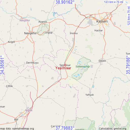
Yeşilhisar GPS coordinates[2]
38° 21' 8.352" North, 35° 5' 19.428" East
| Map corner | latitude | longitude |
|---|---|---|
| Upper-left | 38.90162°, | 34.38561° |
| Center: | 38.35232°, | 35.08873° |
| Lower-right: | 37.79883°, | 35.79186° |
| Map W x H: | 122.6×122.6 km | = 76.2×76.2mi |
| max Lat: | 42.02683° ⇑55.1% North |
| Yeşilhisar: | 38.35232° |
| min Lat: | ⇓44.9% South 35.9025° |
| min Long | Yeşilhisar | max Long |
| 25.90902° | 35.08873° | 44.60099° |
| W 46.1%⇐ | ⇒53.9% E |
Elevation
Elevation of Yeşilhisar is 1100 m = 3609 ft, and this is 382.6 m = 1255 ft above average elevation for this country.
| Max E: |
2682 m = 8799 ft | 25.3% |
| Yeşilhisar | 1100 m 3609 ft | |
| Avg. | 717.4 m = 2354 ft | |
Min E: |
0 m = 0 ft | 74.7% |
See also: Turkey elevation on elevation.city.
Geographical zone
Yeşilhisar is located in North temperate zone (between Tropic of Cancer and the Arctic Circle). Distance of this Northern Tropic circle is 1658.5 km =1030.5 mi to South.| Distance of | km | miles | from Yeşilhisar |
|---|---|---|---|
| North Pole | 5742.7 | 3568.3 | to North |
| Arctic Circle | 3136.8 | 1949.1 | to North |
| Tropic Cancer | 1658.5 | 1030.5 | to South |
| Equator | 4264.4 | 2649.8 | to South |


Nearby cities:
15 places around Yeşilhisar: (largest is in red/bold)
• Acıgöl
55.1 km =34.2 mi,  293°
293°
• Avanos
45.5 km =28.3 mi,  332°
332°
• Derinkuyu
31 km =19.3 mi,  274°
274°
• Develi
35.4 km =22 mi,  83°
83°
• Göreme
39.2 km =24.4 mi, 325°
• Hacılar
45.3 km =28.1 mi,  43°
43°
• Kayseri
54.5 km =33.9 mi, 39°
• Melikgazi
54.2 km =33.7 mi, 35°
• Misli
30.4 km =18.9 mi,  243°
243°
• Nevşehir
44.6 km =27.7 mi,  312°
312°
• Talas
55.3 km =34.4 mi,  47°
47°
• Yahyalı
36.4 km =22.6 mi,  139°
139°
• Özonak
55.5 km =34.5 mi,  337°
337°
• Ürgüp
34.5 km =21.4 mi, 333°
• İncesu
31.1 km =19.3 mi,  15°
15°
Sources, notices
• [Note1] Compared only with cities in Turkey existing in our database
• [Src1] Map data: © OpenStreetMap contributors (CC-BY-SA)
• [Src2] Other city data from geonames.org with taken over terms of usage.
• [Src3] Geographical zone / Annual Mean Temperature by Robert A. Rohde @ Wikipedia
