Elbaşı geodata
Elbaşı (Kayseri) is a seat of a third-order administrative division; located in Turkey in Europe/Istanbul (GMT+3) time zone. In our database, there are 1323 cities with bigger population. Compared to other cities in Turkey, 50.4% of cities are located further ↑North; 50.1% of cities are located further →East and 89.5% of cities have lower elevation than Elbaşı. Note1


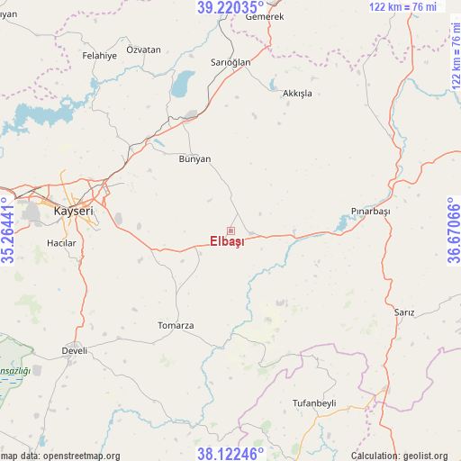
Elbaşı GPS coordinates[2]
38° 40' 24.636" North, 35° 58' 3.108" East
| Map corner | latitude | longitude |
|---|---|---|
| Upper-left | 39.22035°, | 35.26441° |
| Center: | 38.67351°, | 35.96753° |
| Lower-right: | 38.12246°, | 36.67066° |
| Map W x H: | 122.1×122.1 km | = 75.9×75.9mi |
| max Lat: | 42.02683° ⇑50.4% North |
| Elbaşı: | 38.67351° |
| min Lat: | ⇓49.6% South 35.9025° |
| min Long | Elbaşı | max Long |
| 25.90902° | 35.96753° | 44.60099° |
| W 49.9%⇐ | ⇒50.1% E |
Elevation
Elevation of Elbaşı is 1454 m = 4770 ft, and this is 736.6 m = 2417 ft above average elevation for this country.
| Max E: |
2682 m = 8799 ft | 10.5% |
| Elbaşı | 1454 m 4770 ft | |
| Avg. | 717.4 m = 2354 ft | |
Min E: |
0 m = 0 ft | 89.5% |
See also: Turkey elevation on elevation.city.
Geographical zone
Elbaşı is located in North temperate zone (between Tropic of Cancer and the Arctic Circle). Distance of this Northern Tropic circle is 1694.2 km =1052.7 mi to South.| Distance of | km | miles | from Elbaşı |
|---|---|---|---|
| North Pole | 5707 | 3546.2 | to North |
| Arctic Circle | 3101.1 | 1926.9 | to North |
| Tropic Cancer | 1694.2 | 1052.7 | to South |
| Equator | 4300.1 | 2672 | to South |


Nearby cities:
15 places around Elbaşı: (largest is in red/bold)
• Akkışla
40.7 km =25.3 mi,  26°
26°
• Bünyan
21.3 km =13.2 mi,  334°
334°
• Erkilet
48.6 km =30.2 mi,  289°
289°
• Gesi
29.8 km =18.5 mi,  296°
296°
• Hacılar
45.1 km =28 mi,  266°
266°
• Kayseri
42.4 km =26.3 mi,  278°
278°
• Kocasinan
36 km =22.4 mi, 287°
• Melikgazi
45.7 km =28.4 mi, 280°
• Muncusun
39 km =24.2 mi,  310°
310°
• Pazarören
16.7 km =10.4 mi,  89°
89°
• Pınarbaşı
37.3 km =23.2 mi,  81°
81°
• Sarıoğlan
44.9 km =27.9 mi,  359°
359°
• Talas
36 km =22.4 mi, 273°
• Toklar
28.7 km =17.8 mi,  171°
171°
• Tomarza
29.1 km =18.1 mi,  210°
210°
Sources, notices
• [Note1] Compared only with cities in Turkey existing in our database
• [Src1] Map data: © OpenStreetMap contributors (CC-BY-SA)
• [Src2] Other city data from geonames.org with taken over terms of usage.
• [Src3] Geographical zone / Annual Mean Temperature by Robert A. Rohde @ Wikipedia
