Tanır geodata
Tanır (Kahramanmaraş) is a seat of a third-order administrative division; located in Turkey in Europe/Istanbul (GMT+3) time zone. In our database, there are 1323 cities with bigger population. Compared to other cities in Turkey, 54.1% of cities are located further ↑North; 56.4% of cities are located further ←West and 82.1% of cities have lower elevation than Tanır. Note1


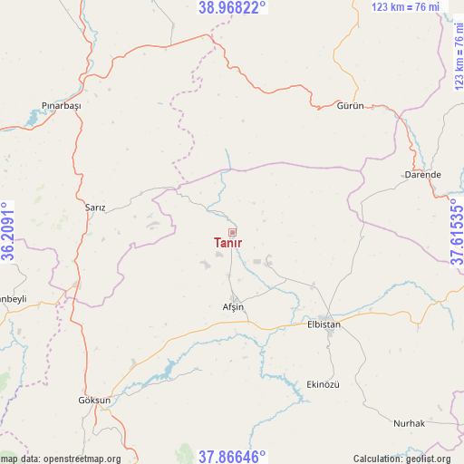
Tanır GPS coordinates[2]
38° 25' 9.984" North, 36° 54' 43.992" East
| Map corner | latitude | longitude |
|---|---|---|
| Upper-left | 38.96822°, | 36.2091° |
| Center: | 38.41944°, | 36.91222° |
| Lower-right: | 37.86646°, | 37.61535° |
| Map W x H: | 122.5×122.5 km | = 76.1×76.1mi |
| max Lat: | 42.02683° ⇑54.1% North |
| Tanır: | 38.41944° |
| min Lat: | ⇓45.9% South 35.9025° |
| min Long | Tanır | max Long |
| 25.90902° | 36.91222° | 44.60099° |
| W 56.4%⇐ | ⇒43.6% E |
Elevation
Elevation of Tanır is 1239 m = 4065 ft, and this is 521.6 m = 1711 ft above average elevation for this country.
| Max E: |
2682 m = 8799 ft | 17.9% |
| Tanır | 1239 m 4065 ft | |
| Avg. | 717.4 m = 2354 ft | |
Min E: |
0 m = 0 ft | 82.1% |
See also: Turkey elevation on elevation.city.
Geographical zone
Tanır is located in North temperate zone (between Tropic of Cancer and the Arctic Circle). Distance of this Northern Tropic circle is 1665.9 km =1035.1 mi to South.| Distance of | km | miles | from Tanır |
|---|---|---|---|
| North Pole | 5735.2 | 3563.7 | to North |
| Arctic Circle | 3129.3 | 1944.5 | to North |
| Tropic Cancer | 1665.9 | 1035.1 | to South |
| Equator | 4271.8 | 2654.4 | to South |


Nearby cities:
15 places around Tanır: (largest is in red/bold)
• Afşin
19.1 km =11.9 mi,  179°
179°
• Balaban
58.2 km =36.2 mi,  85°
85°
• Celeyke
46.7 km =29 mi,  148°
148°
• Darende
53.5 km =33.2 mi,  74°
74°
• Elbistan
34.4 km =21.4 mi,  133°
133°
• Göksun
57.2 km =35.5 mi,  219°
219°
• Gücük
55.6 km =34.5 mi,  116°
116°
• Gürün
45.9 km =28.5 mi,  42°
42°
• Konakpınar
63.6 km =39.5 mi,  31°
31°
• Pınarbaşı
56.3 km =35 mi,  306°
306°
• Sarız
36.6 km =22.7 mi,  280°
280°
• Süleymanlı
61.4 km =38.2 mi,  187°
187°
• Tufanbeyli
62.8 km =39 mi,  253°
253°
• Yazyurdu
42.3 km =26.3 mi,  2°
2°
• Çardak
37.3 km =23.2 mi, 191°
Sources, notices
• [Note1] Compared only with cities in Turkey existing in our database
• [Src1] Map data: © OpenStreetMap contributors (CC-BY-SA)
• [Src2] Other city data from geonames.org with taken over terms of usage.
• [Src3] Geographical zone / Annual Mean Temperature by Robert A. Rohde @ Wikipedia
