Sarız geodata
Sarız (Kayseri) is a seat of a second-order administrative division; located in Turkey in Europe/Istanbul (GMT+3) time zone. With population of 3,990 people, there are 782 cities with bigger population in this country. Compared to other cities in Turkey, 53.2% of cities are located further ↑North; 54.8% of cities are located further ←West and 92.9% of cities have lower elevation than Sarız. Note1


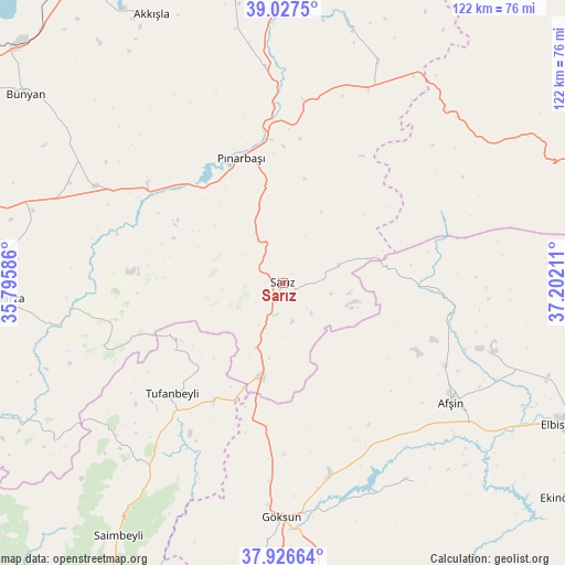
Sarız GPS coordinates[2]
38° 28' 45.012" North, 36° 29' 56.328" East
| Map corner | latitude | longitude |
|---|---|---|
| Upper-left | 39.0275°, | 35.79586° |
| Center: | 38.47917°, | 36.49898° |
| Lower-right: | 37.92664°, | 37.20211° |
| Map W x H: | 122.4×122.4 km | = 76.1×76.1mi |
| max Lat: | 42.02683° ⇑53.2% North |
| Sarız: | 38.47917° |
| min Lat: | ⇓46.8% South 35.9025° |
| min Long | Sarız | max Long |
| 25.90902° | 36.49898° | 44.60099° |
| W 54.8%⇐ | ⇒45.2% E |
Elevation
Elevation of Sarız is 1571 m = 5154 ft, and this is 853.6 m = 2801 ft above average elevation for this country.
| Max E: |
2682 m = 8799 ft | 7.1% |
| Sarız | 1571 m 5154 ft | |
| Avg. | 717.4 m = 2354 ft | |
Min E: |
0 m = 0 ft | 92.9% |
See also: Turkey elevation on elevation.city.
Geographical zone
Sarız is located in North temperate zone (between Tropic of Cancer and the Arctic Circle). Distance of this Northern Tropic circle is 1672.6 km =1039.3 mi to South.| Distance of | km | miles | from Sarız |
|---|---|---|---|
| North Pole | 5728.6 | 3559.6 | to North |
| Arctic Circle | 3122.7 | 1940.4 | to North |
| Tropic Cancer | 1672.6 | 1039.3 | to South |
| Equator | 4278.5 | 2658.5 | to South |


Nearby cities:
15 places around Sarız: (largest is in red/bold)
• Afşin
44.4 km =27.6 mi,  125°
125°
• Akkışla
64.6 km =40.1 mi,  334°
334°
• Elbaşı
51 km =31.7 mi,  295°
295°
• Göksun
50.9 km =31.6 mi,  180°
180°
• Kaynar
46.9 km =29.1 mi,  355°
355°
• Pazarören
36.6 km =22.7 mi,  306°
306°
• Pınarbaşı
28.6 km =17.8 mi,  341°
341°
• Saimbeyli
65.4 km =40.6 mi,  213°
213°
• Tanır
36.6 km =22.7 mi,  100°
100°
• Toklar
42.7 km =26.5 mi,  260°
260°
• Tomarza
61 km =37.9 mi,  266°
266°
• Tufanbeyli
34.1 km =21.2 mi,  225°
225°
• Yazyurdu
51.8 km =32.2 mi,  46°
46°
• Çardak
51.6 km =32.1 mi,  146°
146°
• Örenşehir
59.2 km =36.8 mi,  12°
12°
Sources, notices
• [Note1] Compared only with cities in Turkey existing in our database
• [Src1] Map data: © OpenStreetMap contributors (CC-BY-SA)
• [Src2] Other city data from geonames.org with taken over terms of usage.
• [Src3] Geographical zone / Annual Mean Temperature by Robert A. Rohde @ Wikipedia
