Toklar geodata
Toklar (Kayseri) is a seat of a third-order administrative division; located in Turkey in Europe/Istanbul (GMT+3) time zone. In our database, there are 1323 cities with bigger population. Compared to other cities in Turkey, 54.1% of cities are located further ↑North; 50.2% of cities are located further ←West and 89.4% of cities have lower elevation than Toklar. Note1


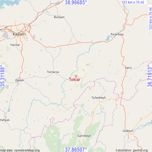
Toklar GPS coordinates[2]
38° 25' 5.016" North, 36° 0' 54" East
| Map corner | latitude | longitude |
|---|---|---|
| Upper-left | 38.96685°, | 35.31188° |
| Center: | 38.41806°, | 36.015° |
| Lower-right: | 37.86507°, | 36.71813° |
| Map W x H: | 122.5×122.5 km | = 76.1×76.1mi |
| max Lat: | 42.02683° ⇑54.1% North |
| Toklar: | 38.41806° |
| min Lat: | ⇓45.9% South 35.9025° |
| min Long | Toklar | max Long |
| 25.90902° | 36.015° | 44.60099° |
| W 50.2%⇐ | ⇒49.8% E |
Elevation
Elevation of Toklar is 1449 m = 4754 ft, and this is 731.6 m = 2400 ft above average elevation for this country.
| Max E: |
2682 m = 8799 ft | 10.6% |
| Toklar | 1449 m 4754 ft | |
| Avg. | 717.4 m = 2354 ft | |
Min E: |
0 m = 0 ft | 89.4% |
See also: Turkey elevation on elevation.city.
Geographical zone
Toklar is located in North temperate zone (between Tropic of Cancer and the Arctic Circle). Distance of this Northern Tropic circle is 1665.8 km =1035.1 mi to South.| Distance of | km | miles | from Toklar |
|---|---|---|---|
| North Pole | 5735.4 | 3563.8 | to North |
| Arctic Circle | 3129.5 | 1944.6 | to North |
| Tropic Cancer | 1665.8 | 1035.1 | to South |
| Equator | 4271.7 | 2654.3 | to South |


Nearby cities:
15 places around Toklar: (largest is in red/bold)
• Bakırdağı
29.8 km =18.5 mi,  221°
221°
• Bünyan
49.5 km =30.8 mi,  344°
344°
• Develi
45.7 km =28.4 mi,  266°
266°
• Elbaşı
28.7 km =17.8 mi,  351°
351°
• Gesi
51.8 km =32.2 mi,  323°
323°
• Hacılar
55.4 km =34.4 mi,  297°
297°
• Kayseri
57.8 km =35.9 mi,  307°
307°
• Kocasinan
55 km =34.2 mi, 315°
• Pazarören
31.1 km =19.3 mi,  23°
23°
• Pınarbaşı
47.2 km =29.3 mi,  44°
44°
• Saimbeyli
48.5 km =30.1 mi,  172°
172°
• Sarız
42.7 km =26.5 mi,  80°
80°
• Talas
50.3 km =31.3 mi, 307°
• Tomarza
19.1 km =11.9 mi,  279°
279°
• Tufanbeyli
24.8 km =15.4 mi,  133°
133°
Sources, notices
• [Note1] Compared only with cities in Turkey existing in our database
• [Src1] Map data: © OpenStreetMap contributors (CC-BY-SA)
• [Src2] Other city data from geonames.org with taken over terms of usage.
• [Src3] Geographical zone / Annual Mean Temperature by Robert A. Rohde @ Wikipedia
