Feke geodata
Feke (Adana) is a seat of a second-order administrative division; located in Turkey in Europe/Istanbul (GMT+3) time zone. With population of 4,592 people, there are 749 cities with bigger population in this country. Compared to other cities in Turkey, 68.2% of cities are located further ↑North; 50.2% of cities are located further →East and 57% of cities have higher elevation than Feke. Note1


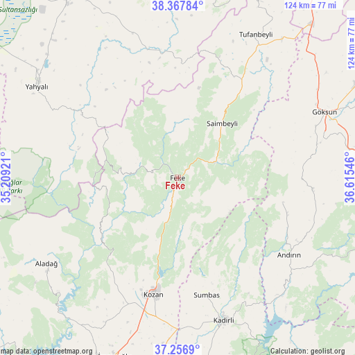
Feke GPS coordinates[2]
37° 48' 52.056" North, 35° 54' 44.388" East
| Map corner | latitude | longitude |
|---|---|---|
| Upper-left | 38.36784°, | 35.20921° |
| Center: | 37.81446°, | 35.91233° |
| Lower-right: | 37.2569°, | 36.61546° |
| Map W x H: | 123.5×123.5 km | = 76.7×76.7mi |
| max Lat: | 42.02683° ⇑68.2% North |
| Feke: | 37.81446° |
| min Lat: | ⇓31.8% South 35.9025° |
| min Long | Feke | max Long |
| 25.90902° | 35.91233° | 44.60099° |
| W 49.8%⇐ | ⇒50.2% E |
Elevation
Elevation of Feke is 552 m = 1811 ft, and this is 165.4 m = 543 ft below average elevation for this country.
| Max E: |
2682 m = 8799 ft | 57% |
| Avg. | 717.4 m = 2354 ft | |
| Feke | 552 m = 1811 ft | |
Min E: |
0 m = 0 ft | 43% |
See also: Turkey elevation on elevation.city.
Geographical zone
Feke is located in North temperate zone (between Tropic of Cancer and the Arctic Circle). Distance of this Northern Tropic circle is 1598.7 km =993.4 mi to South.| Distance of | km | miles | from Feke |
|---|---|---|---|
| North Pole | 5802.5 | 3605.5 | to North |
| Arctic Circle | 3196.6 | 1986.3 | to North |
| Tropic Cancer | 1598.7 | 993.4 | to South |
| Equator | 4204.6 | 2612.6 | to South |


Nearby cities:
15 places around Feke: (largest is in red/bold)
• Aladağ
54.2 km =33.7 mi,  236°
236°
• Andırın
47 km =29.2 mi,  124°
124°
• Bakırdağı
45.9 km =28.5 mi,  346°
346°
• Göksun
56.2 km =34.9 mi,  65°
65°
• Kadirli
51.6 km =32.1 mi,  161°
161°
• Kozan
40.8 km =25.4 mi,  192°
192°
• Mansurlu
23 km =14.3 mi,  279°
279°
• Saimbeyli
24.7 km =15.3 mi,  39°
39°
• Sumbas
41.5 km =25.8 mi,  166°
166°
• Tepecikören
56.3 km =35 mi,  206°
206°
• Toklar
67.7 km =42.1 mi,  7°
7°
• Tufanbeyli
56.7 km =35.2 mi,  28°
28°
• Yahyalı
58.3 km =36.2 mi,  303°
303°
• Çokak
37.6 km =23.4 mi,  103°
103°
• İmamoğlu
65.1 km =40.5 mi,  200°
200°
Sources, notices
• [Note1] Compared only with cities in Turkey existing in our database
• [Src1] Map data: © OpenStreetMap contributors (CC-BY-SA)
• [Src2] Other city data from geonames.org with taken over terms of usage.
• [Src3] Geographical zone / Annual Mean Temperature by Robert A. Rohde @ Wikipedia
