Evciler geodata
Evciler (Afyonkarahisar) is a seat of a second-order administrative division; located in Turkey in Europe/Istanbul (GMT+3) time zone. With population of 4,902 people, there are 731 cities with bigger population in this country. Compared to other cities in Turkey, 60.7% of cities are located further ↑North; 76.5% of cities are located further →East and 61.6% of cities have lower elevation than Evciler. Note1


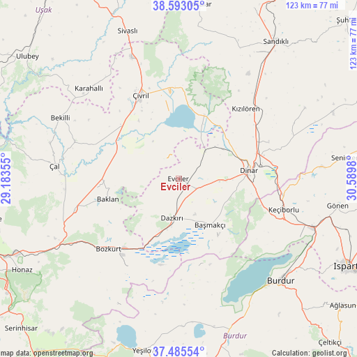
Evciler GPS coordinates[2]
38° 2' 29.004" North, 29° 53' 12.012" East
| Map corner | latitude | longitude |
|---|---|---|
| Upper-left | 38.59305°, | 29.18355° |
| Center: | 38.04139°, | 29.88667° |
| Lower-right: | 37.48554°, | 30.5898° |
| Map W x H: | 123.1×123.1 km | = 76.5×76.5mi |
| max Lat: | 42.02683° ⇑60.7% North |
| Evciler: | 38.04139° |
| min Lat: | ⇓39.3% South 35.9025° |
| min Long | Evciler | max Long |
| 25.90902° | 29.88667° | 44.60099° |
| W 23.5%⇐ | ⇒76.5% E |
Elevation
Elevation of Evciler is 907 m = 2976 ft, and this is 189.6 m = 622 ft above average elevation for this country.
| Max E: |
2682 m = 8799 ft | 38.4% |
| Evciler | 907 m 2976 ft | |
| Avg. | 717.4 m = 2354 ft | |
Min E: |
0 m = 0 ft | 61.6% |
See also: Turkey elevation on elevation.city.
Geographical zone
Evciler is located in North temperate zone (between Tropic of Cancer and the Arctic Circle). Distance of this Northern Tropic circle is 1623.9 km =1009 mi to South.| Distance of | km | miles | from Evciler |
|---|---|---|---|
| North Pole | 5777.3 | 3589.8 | to North |
| Arctic Circle | 3171.4 | 1970.6 | to North |
| Tropic Cancer | 1623.9 | 1009 | to South |
| Equator | 4229.8 | 2628.3 | to South |


Nearby cities:
15 places around Evciler: (largest is in red/bold)
• Baklan
25.4 km =15.8 mi,  253°
253°
• Başmakçı
19.4 km =12.1 mi,  145°
145°
• Bekilli
46 km =28.6 mi,  297°
297°
• Bozkurt
34.3 km =21.3 mi,  225°
225°
• Dazkırı
13.8 km =8.6 mi,  189°
189°
• Dinar
24.6 km =15.3 mi,  83°
83°
• Dombay
30.8 km =19.1 mi,  66°
66°
• Homa
23.7 km =14.7 mi,  21°
21°
• Karahallı
44 km =27.3 mi,  314°
314°
• Keçiborlu
38 km =23.6 mi,  106°
106°
• Kızılören
33.4 km =20.8 mi,  43°
43°
• Çal
43 km =26.7 mi,  276°
276°
• Çardak
30.6 km =19 mi,  218°
218°
• Çivril
31.7 km =19.7 mi,  335°
335°
• İshaklı
20.8 km =12.9 mi,  32°
32°
Sources, notices
• [Note1] Compared only with cities in Turkey existing in our database
• [Src1] Map data: © OpenStreetMap contributors (CC-BY-SA)
• [Src2] Other city data from geonames.org with taken over terms of usage.
• [Src3] Geographical zone / Annual Mean Temperature by Robert A. Rohde @ Wikipedia
