Baklan geodata
Baklan (Denizli) is a seat of a second-order administrative division; located in Turkey in Europe/Istanbul (GMT+3) time zone. With population of 6,756 people, there are 622 cities with bigger population in this country. Compared to other cities in Turkey, 62.1% of cities are located further ↑North; 78.7% of cities are located further →East and 65.5% of cities have lower elevation than Baklan. Note1


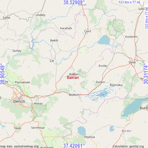
Baklan GPS coordinates[2]
37° 58' 36.984" North, 29° 36' 30.996" East
| Map corner | latitude | longitude |
|---|---|---|
| Upper-left | 38.52909°, | 28.90549° |
| Center: | 37.97694°, | 29.60861° |
| Lower-right: | 37.42061°, | 30.31174° |
| Map W x H: | 123.3×123.3 km | = 76.6×76.6mi |
| max Lat: | 42.02683° ⇑62.1% North |
| Baklan: | 37.97694° |
| min Lat: | ⇓37.9% South 35.9025° |
| min Long | Baklan | max Long |
| 25.90902° | 29.60861° | 44.60099° |
| W 21.3%⇐ | ⇒78.7% E |
Elevation
Elevation of Baklan is 968 m = 3176 ft, and this is 250.6 m = 822 ft above average elevation for this country.
| Max E: |
2682 m = 8799 ft | 34.5% |
| Baklan | 968 m 3176 ft | |
| Avg. | 717.4 m = 2354 ft | |
Min E: |
0 m = 0 ft | 65.5% |
See also: Turkey elevation on elevation.city.
Geographical zone
Baklan is located in North temperate zone (between Tropic of Cancer and the Arctic Circle). Distance of this Northern Tropic circle is 1616.7 km =1004.6 mi to South.| Distance of | km | miles | from Baklan |
|---|---|---|---|
| North Pole | 5784.4 | 3594.3 | to North |
| Arctic Circle | 3178.5 | 1975 | to North |
| Tropic Cancer | 1616.7 | 1004.6 | to South |
| Equator | 4222.6 | 2623.8 | to South |


Nearby cities:
15 places around Baklan: (largest is in red/bold)
• Akkent
28 km =17.4 mi,  314°
314°
• Başmakçı
36.4 km =22.6 mi,  104°
104°
• Bekilli
32.7 km =20.3 mi,  329°
329°
• Bozkurt
17 km =10.6 mi,  179°
179°
• Dazkırı
23 km =14.3 mi,  106°
106°
• Evciler
25.4 km =15.8 mi,  73°
73°
• Gözler
42.4 km =26.3 mi,  289°
289°
• Homa
44.1 km =27.4 mi,  48°
48°
• Honaz
38.5 km =23.9 mi,  230°
230°
• Karahallı
38.8 km =24.1 mi,  349°
349°
• Pamukkale
43.6 km =27.1 mi,  261°
261°
• Çal
21.9 km =13.6 mi,  302°
302°
• Çardak
17.5 km =10.9 mi,  162°
162°
• Çivril
37.8 km =23.5 mi,  17°
17°
• İshaklı
43.2 km =26.8 mi,  55°
55°
Sources, notices
• [Note1] Compared only with cities in Turkey existing in our database
• [Src1] Map data: © OpenStreetMap contributors (CC-BY-SA)
• [Src2] Other city data from geonames.org with taken over terms of usage.
• [Src3] Geographical zone / Annual Mean Temperature by Robert A. Rohde @ Wikipedia
