Dazkırı geodata
Dazkırı (Afyonkarahisar) is a seat of a second-order administrative division; located in Turkey in Europe/Istanbul (GMT+3) time zone. With population of 6,450 people, there are 634 cities with bigger population in this country. Compared to other cities in Turkey, 64% of cities are located further ↑North; 76.8% of cities are located further →East and 60% of cities have lower elevation than Dazkırı. Note1


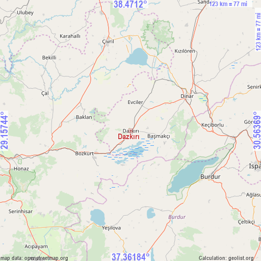
Dazkırı GPS coordinates[2]
37° 55' 6.996" North, 29° 51' 38.016" East
| Map corner | latitude | longitude |
|---|---|---|
| Upper-left | 38.4712°, | 29.15744° |
| Center: | 37.91861°, | 29.86056° |
| Lower-right: | 37.36184°, | 30.56369° |
| Map W x H: | 123.3×123.3 km | = 76.6×76.6mi |
| max Lat: | 42.02683° ⇑64% North |
| Dazkırı: | 37.91861° |
| min Lat: | ⇓36% South 35.9025° |
| min Long | Dazkırı | max Long |
| 25.90902° | 29.86056° | 44.60099° |
| W 23.2%⇐ | ⇒76.8% E |
Elevation
Elevation of Dazkırı is 882 m = 2894 ft, and this is 164.6 m = 540 ft above average elevation for this country.
| Max E: |
2682 m = 8799 ft | 40% |
| Dazkırı | 882 m 2894 ft | |
| Avg. | 717.4 m = 2354 ft | |
Min E: |
0 m = 0 ft | 60% |
See also: Turkey elevation on elevation.city.
Geographical zone
Dazkırı is located in North temperate zone (between Tropic of Cancer and the Arctic Circle). Distance of this Northern Tropic circle is 1610.2 km =1000.5 mi to South.| Distance of | km | miles | from Dazkırı |
|---|---|---|---|
| North Pole | 5790.9 | 3598.3 | to North |
| Arctic Circle | 3185 | 1979.1 | to North |
| Tropic Cancer | 1610.2 | 1000.5 | to South |
| Equator | 4216.2 | 2619.8 | to South |


Nearby cities:
15 places around Dazkırı: (largest is in red/bold)
• Baklan
23 km =14.3 mi,  286°
286°
• Başmakçı
13.5 km =8.4 mi,  100°
100°
• Bozkurt
24.4 km =15.2 mi,  244°
244°
• Burdur
43.8 km =27.2 mi,  120°
120°
• Dinar
31.3 km =19.4 mi,  58°
58°
• Dombay
40.2 km =25 mi,  49°
49°
• Evciler
13.8 km =8.6 mi,  9°
9°
• Homa
37.3 km =23.2 mi,  17°
17°
• Keçiborlu
38.8 km =24.1 mi,  86°
86°
• Kızılören
45.5 km =28.3 mi,  34°
34°
• Yeşilova
46.6 km =29 mi,  191°
191°
• Çal
44.4 km =27.6 mi, 294°
• Çardak
19.7 km =12.2 mi, 238°
• Çivril
43.9 km =27.3 mi,  345°
345°
• İshaklı
34 km =21.1 mi, 23°
Sources, notices
• [Note1] Compared only with cities in Turkey existing in our database
• [Src1] Map data: © OpenStreetMap contributors (CC-BY-SA)
• [Src2] Other city data from geonames.org with taken over terms of usage.
• [Src3] Geographical zone / Annual Mean Temperature by Robert A. Rohde @ Wikipedia
