Çay geodata
Çay (Afyonkarahisar) is a seat of a second-order administrative division; located in Turkey in Europe/Istanbul (GMT+3) time zone. With population of 34,215 people, there are 230 cities with bigger population in this country. Compared to other cities in Turkey, 51.7% of cities are located further ↑North; 70.5% of cities are located further →East and 70.9% of cities have lower elevation than Çay. Note1


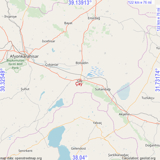
Çay GPS coordinates[2]
38° 35' 30.012" North, 31° 1' 42.996" East
| Map corner | latitude | longitude |
|---|---|---|
| Upper-left | 39.13913°, | 30.32549° |
| Center: | 38.59167°, | 31.02861° |
| Lower-right: | 38.04°, | 31.73174° |
| Map W x H: | 122.2×122.2 km | = 75.9×75.9mi |
| max Lat: | 42.02683° ⇑51.7% North |
| Çay: | 38.59167° |
| min Lat: | ⇓48.3% South 35.9025° |
| min Long | Çay | max Long |
| 25.90902° | 31.02861° | 44.60099° |
| W 29.5%⇐ | ⇒70.5% E |
Elevation
Elevation of Çay is 1039 m = 3409 ft, and this is 321.6 m = 1055 ft above average elevation for this country.
| Max E: |
2682 m = 8799 ft | 29.1% |
| Çay | 1039 m 3409 ft | |
| Avg. | 717.4 m = 2354 ft | |
Min E: |
0 m = 0 ft | 70.9% |
See also: Turkey elevation on elevation.city.
Geographical zone
Çay is located in North temperate zone (between Tropic of Cancer and the Arctic Circle). Distance of this Northern Tropic circle is 1685.1 km =1047.1 mi to South.| Distance of | km | miles | from Çay |
|---|---|---|---|
| North Pole | 5716.1 | 3551.8 | to North |
| Arctic Circle | 3110.2 | 1932.6 | to North |
| Tropic Cancer | 1685.1 | 1047.1 | to South |
| Equator | 4291 | 2666.3 | to South |


Nearby cities:
15 places around Çay: (largest is in red/bold)
• Afyonkarahisar
45.9 km =28.5 mi,  293°
293°
• Akşehir
42.6 km =26.5 mi,  127°
127°
• Bayat
44.4 km =27.6 mi,  348°
348°
• Bağkonak
46.7 km =29 mi,  152°
152°
• Bolvadin
13.4 km =8.3 mi,  7°
7°
• Davulga
52.3 km =32.5 mi,  34°
34°
• Emirdağ
48.7 km =30.3 mi, 12°
• Gelendost
52.4 km =32.6 mi,  181°
181°
• Işıklar
26.5 km =16.5 mi, 289°
• Kumdanlı
30.1 km =18.7 mi,  188°
188°
• Sultandağı
18.6 km =11.6 mi,  111°
111°
• Yalvaç
35.4 km =22 mi,  158°
158°
• Çobanlar
24.6 km =15.3 mi,  299°
299°
• İscehisar
38.5 km =23.9 mi,  321°
321°
• Şuhut
42.5 km =26.4 mi,  260°
260°
Sources, notices
• [Note1] Compared only with cities in Turkey existing in our database
• [Src1] Map data: © OpenStreetMap contributors (CC-BY-SA)
• [Src2] Other city data from geonames.org with taken over terms of usage.
• [Src3] Geographical zone / Annual Mean Temperature by Robert A. Rohde @ Wikipedia
