Ekmekçiler geodata
Ekmekçiler (Siirt) is a populated place; located in Turkey in Europe/Istanbul (GMT+3) time zone. With population of 577 people, there are 1266 cities with bigger population in this country. Compared to other cities in Turkey, 65.6% of cities are located further ↑North; 91.4% of cities are located further ←West and 87.9% of cities have lower elevation than Ekmekçiler. Note1


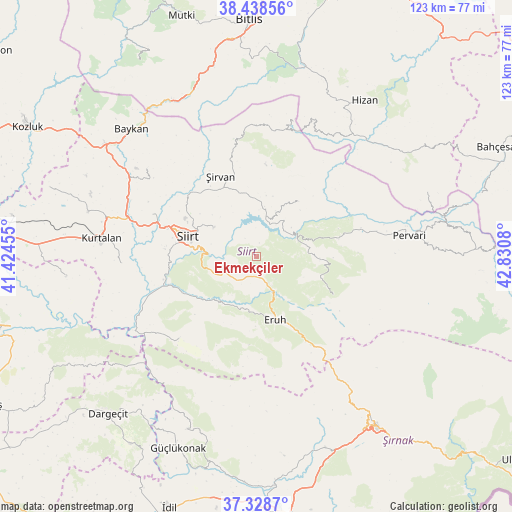
Ekmekçiler GPS coordinates[2]
37° 53' 8.592" North, 42° 7' 39.612" East
| Map corner | latitude | longitude |
|---|---|---|
| Upper-left | 38.43856°, | 41.42455° |
| Center: | 37.88572°, | 42.12767° |
| Lower-right: | 37.3287°, | 42.8308° |
| Map W x H: | 123.4×123.4 km | = 76.7×76.7mi |
| max Lat: | 42.02683° ⇑65.6% North |
| Ekmekçiler: | 37.88572° |
| min Lat: | ⇓34.4% South 35.9025° |
| min Long | Ekmekçiler | max Long |
| 25.90902° | 42.12767° | 44.60099° |
| W 91.4%⇐ | ⇒8.6% E |
Elevation
Elevation of Ekmekçiler is 1395 m = 4577 ft, and this is 677.6 m = 2223 ft above average elevation for this country.
| Max E: |
2682 m = 8799 ft | 12.1% |
| Ekmekçiler | 1395 m 4577 ft | |
| Avg. | 717.4 m = 2354 ft | |
Min E: |
0 m = 0 ft | 87.9% |
See also: Turkey elevation on elevation.city.
Geographical zone
Ekmekçiler is located in North temperate zone (between Tropic of Cancer and the Arctic Circle). Distance of this Northern Tropic circle is 1606.6 km =998.3 mi to South.| Distance of | km | miles | from Ekmekçiler |
|---|---|---|---|
| North Pole | 5794.6 | 3600.6 | to North |
| Arctic Circle | 3188.7 | 1981.4 | to North |
| Tropic Cancer | 1606.6 | 998.3 | to South |
| Equator | 4212.5 | 2617.5 | to South |


Nearby cities:
15 places around Ekmekçiler: (largest is in red/bold)
• Dikboğaz
21.3 km =13.2 mi,  184°
184°
• Doluharman
21.6 km =13.4 mi,  300°
300°
• Doğanca
20.3 km =12.6 mi,  118°
118°
• Durankaya
12.1 km =7.5 mi,  22°
22°
• Eruh
16.5 km =10.3 mi,  165°
165°
• Gölgelikonak
13 km =8.1 mi, 180°
• Karasungur
18.6 km =11.6 mi,  90°
90°
• Meydandere
5.2 km =3.2 mi,  328°
328°
• Palamutlu
6.7 km =4.2 mi,  80°
80°
• Siirt
17 km =10.6 mi,  286°
286°
• Taşdibek
16.4 km =10.2 mi,  63°
63°
• Taşlı
11.3 km =7 mi,  3°
3°
• Tillo
12.3 km =7.6 mi, 304°
• Özpınar
16.7 km =10.4 mi,  37°
37°
• İkizbağlar
17.1 km =10.6 mi,  307°
307°
Sources, notices
• [Note1] Compared only with cities in Turkey existing in our database
• [Src1] Map data: © OpenStreetMap contributors (CC-BY-SA)
• [Src2] Other city data from geonames.org with taken over terms of usage.
• [Src3] Geographical zone / Annual Mean Temperature by Robert A. Rohde @ Wikipedia
