Akçakent geodata
Akçakent (Kırşehir) is a seat of a second-order administrative division; located in Turkey in Europe/Istanbul (GMT+3) time zone. In our database, there are 1323 cities with bigger population. Compared to other cities in Turkey, 63.3% of cities are located further ↓South; 58% of cities are located further →East and 87.9% of cities have lower elevation than Akçakent. Note1


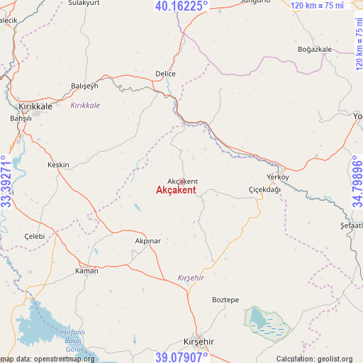
Akçakent GPS coordinates[2]
39° 37' 22.008" North, 34° 5' 44.988" East
| Map corner | latitude | longitude |
|---|---|---|
| Upper-left | 40.16225°, | 33.39271° |
| Center: | 39.62278°, | 34.09583° |
| Lower-right: | 39.07907°, | 34.79896° |
| Map W x H: | 120.4×120.4 km | = 74.8×74.8mi |
| max Lat: | 42.02683° ⇑36.7% North |
| Akçakent: | 39.62278° |
| min Lat: | ⇓63.3% South 35.9025° |
| min Long | Akçakent | max Long |
| 25.90902° | 34.09583° | 44.60099° |
| W 42%⇐ | ⇒58% E |
Elevation
Elevation of Akçakent is 1395 m = 4577 ft, and this is 677.6 m = 2223 ft above average elevation for this country.
| Max E: |
2682 m = 8799 ft | 12.1% |
| Akçakent | 1395 m 4577 ft | |
| Avg. | 717.4 m = 2354 ft | |
Min E: |
0 m = 0 ft | 87.9% |
See also: Turkey elevation on elevation.city.
Geographical zone
Akçakent is located in North temperate zone (between Tropic of Cancer and the Arctic Circle). Distance of this Northern Tropic circle is 1799.7 km =1118.3 mi to South.| Distance of | km | miles | from Akçakent |
|---|---|---|---|
| North Pole | 5601.4 | 3480.5 | to North |
| Arctic Circle | 2995.5 | 1861.3 | to North |
| Tropic Cancer | 1799.7 | 1118.3 | to South |
| Equator | 4405.6 | 2737.5 | to South |


Nearby cities:
15 places around Akçakent: (largest is in red/bold)
• Akpınar
22.2 km =13.8 mi,  210°
210°
• Balışeyh
45.4 km =28.2 mi,  315°
315°
• Boztepe
41.7 km =25.9 mi,  160°
160°
• Delice
37.3 km =23.2 mi,  350°
350°
• Göllü
26 km =16.2 mi,  137°
137°
• Kaman
43.5 km =27 mi,  227°
227°
• Keskin
41.7 km =25.9 mi,  277°
277°
• Kösefakılı
4.7 km =2.9 mi,  132°
132°
• Kırıkkale
56.1 km =34.9 mi,  296°
296°
• Kırşehir
53.4 km =33.2 mi,  173°
173°
• Musabeyli
50.8 km =31.6 mi,  62°
62°
• Salmanlı
33.9 km =21.1 mi,  23°
23°
• Yerköy
31.8 km =19.8 mi,  86°
86°
• Çelebi
52.1 km =32.4 mi,  250°
250°
• Çiçekdağı
26.8 km =16.7 mi, 93°
Sources, notices
• [Note1] Compared only with cities in Turkey existing in our database
• [Src1] Map data: © OpenStreetMap contributors (CC-BY-SA)
• [Src2] Other city data from geonames.org with taken over terms of usage.
• [Src3] Geographical zone / Annual Mean Temperature by Robert A. Rohde @ Wikipedia
