Delice geodata
Delice (Kırıkkale) is a seat of a second-order administrative division; located in Turkey in Europe/Istanbul (GMT+3) time zone. With population of 12,286 people, there are 445 cities with bigger population in this country. Compared to other cities in Turkey, 68.4% of cities are located further ↓South; 58.2% of cities are located further →East and 53.2% of cities have lower elevation than Delice. Note1


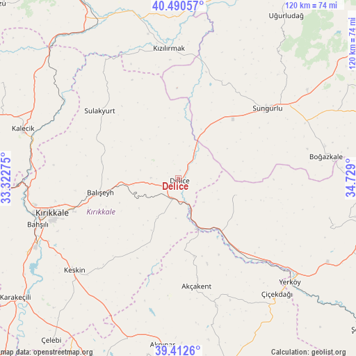
Delice GPS coordinates[2]
39° 57' 13.356" North, 34° 1' 33.132" East
| Map corner | latitude | longitude |
|---|---|---|
| Upper-left | 40.49057°, | 33.32275° |
| Center: | 39.95371°, | 34.02587° |
| Lower-right: | 39.4126°, | 34.729° |
| Map W x H: | 119.9×119.9 km | = 74.5×74.5mi |
| max Lat: | 42.02683° ⇑31.6% North |
| Delice: | 39.95371° |
| min Lat: | ⇓68.4% South 35.9025° |
| min Long | Delice | max Long |
| 25.90902° | 34.02587° | 44.60099° |
| W 41.8%⇐ | ⇒58.2% E |
Elevation
Elevation of Delice is 760 m = 2493 ft, and this is 42.6 m = 140 ft above average elevation for this country.
| Max E: |
2682 m = 8799 ft | 46.8% |
| Delice | 760 m 2493 ft | |
| Avg. | 717.4 m = 2354 ft | |
Min E: |
0 m = 0 ft | 53.2% |
See also: Turkey elevation on elevation.city.
Geographical zone
Delice is located in North temperate zone (between Tropic of Cancer and the Arctic Circle). Distance of this Northern Tropic circle is 1836.5 km =1141.1 mi to South.| Distance of | km | miles | from Delice |
|---|---|---|---|
| North Pole | 5564.6 | 3457.7 | to North |
| Arctic Circle | 2958.7 | 1838.5 | to North |
| Tropic Cancer | 1836.5 | 1141.1 | to South |
| Equator | 4442.4 | 2760.4 | to South |


Nearby cities:
15 places around Delice: (largest is in red/bold)
• Akçakent
37.3 km =23.2 mi,  170°
170°
• Bahşılı
53.1 km =33 mi,  251°
251°
• Balışeyh
26.2 km =16.3 mi,  260°
260°
• Boğazkale
50.3 km =31.3 mi,  81°
81°
• Keskin
47 km =29.2 mi,  228°
228°
• Kösefakılı
41.1 km =25.5 mi, 166°
• Kırıkkale
45.9 km =28.5 mi, 254°
• Kızılırmak
43.7 km =27.2 mi,  355°
355°
• Musabeyli
52.7 km =32.7 mi,  104°
104°
• Salmanlı
20.3 km =12.6 mi,  106°
106°
• Sulakyurt
34.8 km =21.6 mi,  310°
310°
• Sungurlu
38 km =23.6 mi,  51°
51°
• Yahşihan
50.2 km =31.2 mi, 256°
• Yerköy
51.5 km =32 mi,  132°
132°
• Çiçekdağı
50.6 km =31.4 mi,  139°
139°
Sources, notices
• [Note1] Compared only with cities in Turkey existing in our database
• [Src1] Map data: © OpenStreetMap contributors (CC-BY-SA)
• [Src2] Other city data from geonames.org with taken over terms of usage.
• [Src3] Geographical zone / Annual Mean Temperature by Robert A. Rohde @ Wikipedia
