Boztepe geodata
Boztepe (Kırşehir) is a seat of a second-order administrative division; located in Turkey in Europe/Istanbul (GMT+3) time zone. In our database, there are 1323 cities with bigger population. Compared to other cities in Turkey, 58.6% of cities are located further ↓South; 57.6% of cities are located further →East and 79.4% of cities have lower elevation than Boztepe. Note1


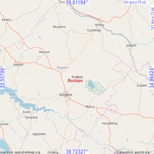
Boztepe GPS coordinates[2]
39° 16' 10.992" North, 34° 15' 39.996" East
| Map corner | latitude | longitude |
|---|---|---|
| Upper-left | 39.81194°, | 33.55799° |
| Center: | 39.26972°, | 34.26111° |
| Lower-right: | 38.72327°, | 34.96424° |
| Map W x H: | 121×121 km | = 75.2×75.2mi |
| max Lat: | 42.02683° ⇑41.4% North |
| Boztepe: | 39.26972° |
| min Lat: | ⇓58.6% South 35.9025° |
| min Long | Boztepe | max Long |
| 25.90902° | 34.26111° | 44.60099° |
| W 42.4%⇐ | ⇒57.6% E |
Elevation
Elevation of Boztepe is 1181 m = 3875 ft, and this is 463.6 m = 1521 ft above average elevation for this country.
| Max E: |
2682 m = 8799 ft | 20.6% |
| Boztepe | 1181 m 3875 ft | |
| Avg. | 717.4 m = 2354 ft | |
Min E: |
0 m = 0 ft | 79.4% |
See also: Turkey elevation on elevation.city.
Geographical zone
Boztepe is located in North temperate zone (between Tropic of Cancer and the Arctic Circle). Distance of this Northern Tropic circle is 1760.5 km =1093.9 mi to South.| Distance of | km | miles | from Boztepe |
|---|---|---|---|
| North Pole | 5640.7 | 3505 | to North |
| Arctic Circle | 3034.8 | 1885.7 | to North |
| Tropic Cancer | 1760.5 | 1093.9 | to South |
| Equator | 4366.4 | 2713.2 | to South |


Nearby cities:
15 places around Boztepe: (largest is in red/bold)
• Akpınar
32.4 km =20.1 mi,  308°
308°
• Akçakent
41.7 km =25.9 mi,  340°
340°
• Evren
47.8 km =29.7 mi,  235°
235°
• Göllü
20.3 km =12.6 mi,  9°
9°
• Hacıbektaş
44.6 km =27.7 mi,  145°
145°
• Kaman
47.2 km =29.3 mi,  281°
281°
• Karahasanlı
39.7 km =24.7 mi,  85°
85°
• Kösefakılı
37.6 km =23.4 mi, 343°
• Kırşehir
16.1 km =10 mi,  211°
211°
• Mucur
25.4 km =15.8 mi,  155°
155°
• Sarıyahşi
48.2 km =30 mi,  228°
228°
• Savcılı
50.1 km =31.1 mi,  264°
264°
• Yerköy
44.6 km =27.7 mi,  23°
23°
• Çiçekdağı
39.6 km =24.6 mi, 18°
• Şefaatlı
49.9 km =31 mi,  58°
58°
Sources, notices
• [Note1] Compared only with cities in Turkey existing in our database
• [Src1] Map data: © OpenStreetMap contributors (CC-BY-SA)
• [Src2] Other city data from geonames.org with taken over terms of usage.
• [Src3] Geographical zone / Annual Mean Temperature by Robert A. Rohde @ Wikipedia
