Şuhut geodata
Şuhut (Afyonkarahisar) is a seat of a second-order administrative division; located in Turkey in Europe/Istanbul (GMT+3) time zone. With population of 13,842 people, there are 410 cities with bigger population in this country. Compared to other cities in Turkey, 52.5% of cities are located further ↑North; 72.7% of cities are located further →East and 77% of cities have lower elevation than Şuhut. Note1


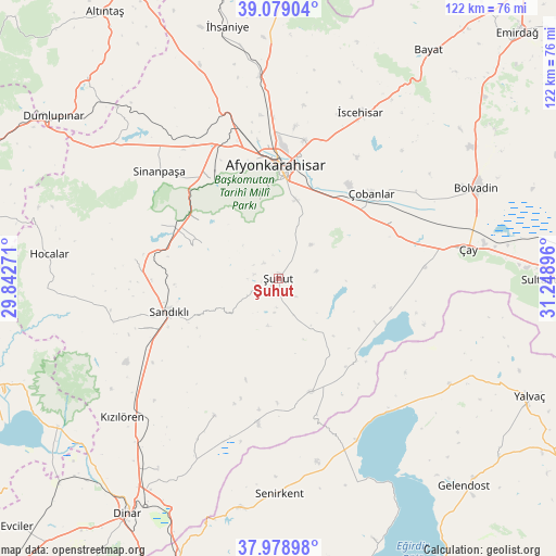
Şuhut GPS coordinates[2]
38° 31' 51.996" North, 30° 32' 44.988" East
| Map corner | latitude | longitude |
|---|---|---|
| Upper-left | 39.07904°, | 29.84271° |
| Center: | 38.53111°, | 30.54583° |
| Lower-right: | 37.97898°, | 31.24896° |
| Map W x H: | 122.3×122.3 km | = 76×76mi |
| max Lat: | 42.02683° ⇑52.5% North |
| Şuhut: | 38.53111° |
| min Lat: | ⇓47.5% South 35.9025° |
| min Long | Şuhut | max Long |
| 25.90902° | 30.54583° | 44.60099° |
| W 27.3%⇐ | ⇒72.7% E |
Elevation
Elevation of Şuhut is 1138 m = 3734 ft, and this is 420.6 m = 1380 ft above average elevation for this country.
| Max E: |
2682 m = 8799 ft | 23% |
| Şuhut | 1138 m 3734 ft | |
| Avg. | 717.4 m = 2354 ft | |
Min E: |
0 m = 0 ft | 77% |
See also: Turkey elevation on elevation.city.
Geographical zone
Şuhut is located in North temperate zone (between Tropic of Cancer and the Arctic Circle). Distance of this Northern Tropic circle is 1678.3 km =1042.8 mi to South.| Distance of | km | miles | from Şuhut |
|---|---|---|---|
| North Pole | 5722.8 | 3556 | to North |
| Arctic Circle | 3116.9 | 1936.8 | to North |
| Tropic Cancer | 1678.3 | 1042.8 | to South |
| Equator | 4284.3 | 2662.1 | to South |


Nearby cities:
15 places around Şuhut: (largest is in red/bold)
• Afyonkarahisar
25.1 km =15.6 mi,  359°
359°
• Bolvadin
48 km =29.8 mi,  65°
65°
• Haydarlı
33.2 km =20.6 mi,  204°
204°
• Hocalar
50.5 km =31.4 mi,  275°
275°
• Işıklar
23 km =14.3 mi,  47°
47°
• Karadirek
31.7 km =19.7 mi, 277°
• Kumdanlı
44 km =27.3 mi,  121°
121°
• Kızılören
45.8 km =28.5 mi,  228°
228°
• Sandıklı
25.2 km =15.7 mi,  252°
252°
• Senirkent
47.4 km =29.5 mi,  179°
179°
• Sinanpaşa
35.4 km =22 mi,  312°
312°
• Uluborlu
51 km =31.7 mi,  189°
189°
• Çay
42.5 km =26.4 mi,  80°
80°
• Çobanlar
28 km =17.4 mi, 47°
• İscehisar
40.8 km =25.4 mi,  25°
25°
Sources, notices
• [Note1] Compared only with cities in Turkey existing in our database
• [Src1] Map data: © OpenStreetMap contributors (CC-BY-SA)
• [Src2] Other city data from geonames.org with taken over terms of usage.
• [Src3] Geographical zone / Annual Mean Temperature by Robert A. Rohde @ Wikipedia
