Halkapınar geodata
Halkapınar (Konya) is a seat of a second-order administrative division; located in Turkey in Europe/Istanbul (GMT+3) time zone. With population of 2,101 people, there are 938 cities with bigger population in this country. Compared to other cities in Turkey, 76.6% of cities are located further ↑North; 57.8% of cities are located further →East and 78.6% of cities have lower elevation than Halkapınar. Note1


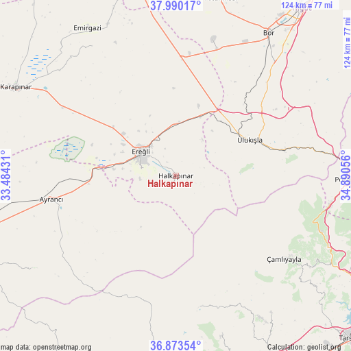
Halkapınar GPS coordinates[2]
37° 26' 2.184" North, 34° 11' 14.748" East
| Map corner | latitude | longitude |
|---|---|---|
| Upper-left | 37.99017°, | 33.48431° |
| Center: | 37.43394°, | 34.18743° |
| Lower-right: | 36.87354°, | 34.89056° |
| Map W x H: | 124.2×124.2 km | = 77.2×77.2mi |
| max Lat: | 42.02683° ⇑76.6% North |
| Halkapınar: | 37.43394° |
| min Lat: | ⇓23.4% South 35.9025° |
| min Long | Halkapınar | max Long |
| 25.90902° | 34.18743° | 44.60099° |
| W 42.2%⇐ | ⇒57.8% E |
Elevation
Elevation of Halkapınar is 1167 m = 3829 ft, and this is 449.6 m = 1475 ft above average elevation for this country.
| Max E: |
2682 m = 8799 ft | 21.4% |
| Halkapınar | 1167 m 3829 ft | |
| Avg. | 717.4 m = 2354 ft | |
Min E: |
0 m = 0 ft | 78.6% |
See also: Turkey elevation on elevation.city.
Geographical zone
Halkapınar is located in North temperate zone (between Tropic of Cancer and the Arctic Circle). Distance of this Northern Tropic circle is 1556.3 km =967 mi to South.| Distance of | km | miles | from Halkapınar |
|---|---|---|---|
| North Pole | 5844.8 | 3631.8 | to North |
| Arctic Circle | 3238.9 | 2012.6 | to North |
| Tropic Cancer | 1556.3 | 967 | to South |
| Equator | 4162.3 | 2586.3 | to South |


Nearby cities:
15 places around Halkapınar: (largest is in red/bold)
• Altunhisar
64.1 km =39.8 mi,  14°
14°
• Arslanköy
47 km =29.2 mi,  169°
169°
• Ayrancı
44.8 km =27.8 mi,  259°
259°
• Beyviran
54.5 km =33.9 mi,  328°
328°
• Bor
60.4 km =37.5 mi,  32°
32°
• Emirgazi
60.5 km =37.6 mi, 329°
• Ereğli
15.2 km =9.4 mi,  305°
305°
• Gözne
59.5 km =37 mi,  145°
145°
• Karapınar
64.3 km =40 mi,  299°
299°
• Kemerhisar
55 km =34.2 mi,  37°
37°
• Pozantı
60.4 km =37.5 mi,  90°
90°
• Ulukışla
29.2 km =18.1 mi,  64°
64°
• Çamlıyayla
46.6 km =29 mi,  129°
129°
• Çiftehan
52.1 km =32.4 mi,  80°
80°
• İnönü
39.4 km =24.5 mi,  250°
250°
Sources, notices
• [Note1] Compared only with cities in Turkey existing in our database
• [Src1] Map data: © OpenStreetMap contributors (CC-BY-SA)
• [Src2] Other city data from geonames.org with taken over terms of usage.
• [Src3] Geographical zone / Annual Mean Temperature by Robert A. Rohde @ Wikipedia
