Pozantı geodata
Pozantı (Adana) is a seat of a second-order administrative division; located in Turkey in Europe/Istanbul (GMT+3) time zone. With population of 10,517 people, there are 497 cities with bigger population in this country. Compared to other cities in Turkey, 76.7% of cities are located further ↑North; 54.7% of cities are located further →East and 57.1% of cities have lower elevation than Pozantı. Note1


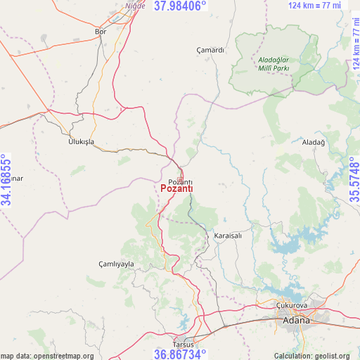
Pozantı GPS coordinates[2]
37° 25' 40.008" North, 34° 52' 18.012" East
| Map corner | latitude | longitude |
|---|---|---|
| Upper-left | 37.98406°, | 34.16855° |
| Center: | 37.42778°, | 34.87167° |
| Lower-right: | 36.86734°, | 35.5748° |
| Map W x H: | 124.2×124.2 km | = 77.2×77.2mi |
| max Lat: | 42.02683° ⇑76.7% North |
| Pozantı: | 37.42778° |
| min Lat: | ⇓23.3% South 35.9025° |
| min Long | Pozantı | max Long |
| 25.90902° | 34.87167° | 44.60099° |
| W 45.3%⇐ | ⇒54.7% E |
Elevation
Elevation of Pozantı is 827 m = 2713 ft, and this is 109.6 m = 360 ft above average elevation for this country.
| Max E: |
2682 m = 8799 ft | 42.9% |
| Pozantı | 827 m 2713 ft | |
| Avg. | 717.4 m = 2354 ft | |
Min E: |
0 m = 0 ft | 57.1% |
See also: Turkey elevation on elevation.city.
Geographical zone
Pozantı is located in North temperate zone (between Tropic of Cancer and the Arctic Circle). Distance of this Northern Tropic circle is 1555.7 km =966.7 mi to South.| Distance of | km | miles | from Pozantı |
|---|---|---|---|
| North Pole | 5845.5 | 3632.2 | to North |
| Arctic Circle | 3239.6 | 2013 | to North |
| Tropic Cancer | 1555.7 | 966.7 | to South |
| Equator | 4161.6 | 2585.9 | to South |


Nearby cities:
15 places around Pozantı: (largest is in red/bold)
• Aladağ
48.2 km =30 mi,  73°
73°
• Bor
58.4 km =36.3 mi,  331°
331°
• Gözne
54.9 km =34.1 mi,  208°
208°
• Halkapınar
60.4 km =37.5 mi,  270°
270°
• Kamışlı
15.7 km =9.8 mi,  25°
25°
• Karaisalı
25.2 km =15.7 mi,  138°
138°
• Kemerhisar
51.4 km =31.9 mi, 329°
• Niğde
62.2 km =38.6 mi,  344°
344°
• Tarsus
56.8 km =35.3 mi,  178°
178°
• Ulukışla
36.6 km =22.7 mi,  291°
291°
• Yenice
52.6 km =32.7 mi,  162°
162°
• Çamardı
46 km =28.6 mi,  12°
12°
• Çamlıyayla
38.1 km =23.7 mi,  220°
220°
• Çatalan
42.1 km =26.2 mi,  118°
118°
• Çiftehan
13 km =8.1 mi,  316°
316°
Sources, notices
• [Note1] Compared only with cities in Turkey existing in our database
• [Src1] Map data: © OpenStreetMap contributors (CC-BY-SA)
• [Src2] Other city data from geonames.org with taken over terms of usage.
• [Src3] Geographical zone / Annual Mean Temperature by Robert A. Rohde @ Wikipedia
