Kamışlı geodata
Kamışlı (Adana) is a seat of a third-order administrative division; located in Turkey in Europe/Istanbul (GMT+3) time zone. In our database, there are 1323 cities with bigger population. Compared to other cities in Turkey, 73.5% of cities are located further ↑North; 54.5% of cities are located further →East and 77.3% of cities have lower elevation than Kamışlı. Note1


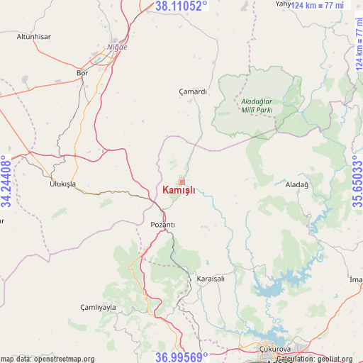
Kamışlı GPS coordinates[2]
37° 33' 18.684" North, 34° 56' 49.92" East
| Map corner | latitude | longitude |
|---|---|---|
| Upper-left | 38.11052°, | 34.24408° |
| Center: | 37.55519°, | 34.9472° |
| Lower-right: | 36.99569°, | 35.65033° |
| Map W x H: | 124×124 km | = 77.1×77.1mi |
| max Lat: | 42.02683° ⇑73.5% North |
| Kamışlı: | 37.55519° |
| min Lat: | ⇓26.5% South 35.9025° |
| min Long | Kamışlı | max Long |
| 25.90902° | 34.9472° | 44.60099° |
| W 45.5%⇐ | ⇒54.5% E |
Elevation
Elevation of Kamışlı is 1141 m = 3743 ft, and this is 423.6 m = 1390 ft above average elevation for this country.
| Max E: |
2682 m = 8799 ft | 22.7% |
| Kamışlı | 1141 m 3743 ft | |
| Avg. | 717.4 m = 2354 ft | |
Min E: |
0 m = 0 ft | 77.3% |
See also: Turkey elevation on elevation.city.
Geographical zone
Kamışlı is located in North temperate zone (between Tropic of Cancer and the Arctic Circle). Distance of this Northern Tropic circle is 1569.8 km =975.4 mi to South.| Distance of | km | miles | from Kamışlı |
|---|---|---|---|
| North Pole | 5831.3 | 3623.4 | to North |
| Arctic Circle | 3225.4 | 2004.2 | to North |
| Tropic Cancer | 1569.8 | 975.4 | to South |
| Equator | 4175.7 | 2594.7 | to South |


Nearby cities:
15 places around Kamışlı: (largest is in red/bold)
• Aladağ
39.6 km =24.6 mi,  91°
91°
• Bor
50.6 km =31.4 mi,  317°
317°
• Halkapınar
68.4 km =42.5 mi,  258°
258°
• Karaisalı
34.6 km =21.5 mi,  163°
163°
• Kemerhisar
44.6 km =27.7 mi,  312°
312°
• Niğde
51.4 km =31.9 mi,  332°
332°
• Pozantı
15.7 km =9.8 mi,  205°
205°
• Sarıçam
66.8 km =41.5 mi,  132°
132°
• Tepecikören
63.7 km =39.6 mi,  109°
109°
• Ulukışla
40.7 km =25.3 mi,  268°
268°
• Yenice
64.9 km =40.3 mi,  171°
171°
• Çamardı
30.9 km =19.2 mi,  5°
5°
• Çamlıyayla
53.4 km =33.2 mi,  215°
215°
• Çatalan
45.7 km =28.4 mi,  138°
138°
• Çiftehan
16.4 km =10.2 mi,  253°
253°
Sources, notices
• [Note1] Compared only with cities in Turkey existing in our database
• [Src1] Map data: © OpenStreetMap contributors (CC-BY-SA)
• [Src2] Other city data from geonames.org with taken over terms of usage.
• [Src3] Geographical zone / Annual Mean Temperature by Robert A. Rohde @ Wikipedia
