Beylikova geodata
Beylikova (Eskişehir) is a seat of a second-order administrative division; located in Turkey in Europe/Istanbul (GMT+3) time zone. With population of 5,131 people, there are 710 cities with bigger population in this country. Compared to other cities in Turkey, 64% of cities are located further ↓South; 69.6% of cities are located further →East and 53.6% of cities have lower elevation than Beylikova. Note1


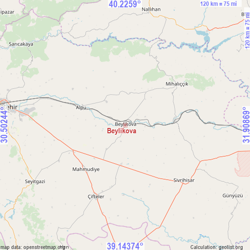
Beylikova GPS coordinates[2]
39° 41' 12.984" North, 31° 12' 20.016" East
| Map corner | latitude | longitude |
|---|---|---|
| Upper-left | 40.2259°, | 30.50244° |
| Center: | 39.68694°, | 31.20556° |
| Lower-right: | 39.14374°, | 31.90869° |
| Map W x H: | 120.3×120.3 km | = 74.8×74.8mi |
| max Lat: | 42.02683° ⇑36% North |
| Beylikova: | 39.68694° |
| min Lat: | ⇓64% South 35.9025° |
| min Long | Beylikova | max Long |
| 25.90902° | 31.20556° | 44.60099° |
| W 30.4%⇐ | ⇒69.6% E |
Elevation
Elevation of Beylikova is 768 m = 2520 ft, and this is 50.6 m = 166 ft above average elevation for this country.
| Max E: |
2682 m = 8799 ft | 46.4% |
| Beylikova | 768 m 2520 ft | |
| Avg. | 717.4 m = 2354 ft | |
Min E: |
0 m = 0 ft | 53.6% |
See also: Turkey elevation on elevation.city.
Geographical zone
Beylikova is located in North temperate zone (between Tropic of Cancer and the Arctic Circle). Distance of this Northern Tropic circle is 1806.9 km =1122.8 mi to South.| Distance of | km | miles | from Beylikova |
|---|---|---|---|
| North Pole | 5594.3 | 3476.1 | to North |
| Arctic Circle | 2988.4 | 1856.9 | to North |
| Tropic Cancer | 1806.9 | 1122.8 | to South |
| Equator | 4412.8 | 2742 | to South |


Nearby cities:
15 places around Beylikova: (largest is in red/bold)
• Alpu
22.8 km =14.2 mi,  293°
293°
• Bozan
14.3 km =8.9 mi,  321°
321°
• Eskişehir
59.4 km =36.9 mi,  279°
279°
• Hekimdağ
60.1 km =37.3 mi, 294°
• Kaymaz
19.1 km =11.9 mi,  186°
186°
• Mahmudiye
28.1 km =17.5 mi,  221°
221°
• Mihalıçcık
31.8 km =19.8 mi,  51°
51°
• Nallıhan
56.9 km =35.4 mi,  12°
12°
• Odunpazarı
58 km =36 mi, 278°
• Sevinç
45.4 km =28.2 mi, 283°
• Seyitgazi
51.4 km =31.9 mi,  238°
238°
• Sivrihisar
38.5 km =23.9 mi,  133°
133°
• Tepebaşı
59.7 km =37.1 mi, 283°
• Umraniye
57 km =35.4 mi,  177°
177°
• Çifteler
36.7 km =22.8 mi,  202°
202°
Sources, notices
• [Note1] Compared only with cities in Turkey existing in our database
• [Src1] Map data: © OpenStreetMap contributors (CC-BY-SA)
• [Src2] Other city data from geonames.org with taken over terms of usage.
• [Src3] Geographical zone / Annual Mean Temperature by Robert A. Rohde @ Wikipedia
