Mihalıçcık geodata
Mihalıçcık (Eskişehir) is a seat of a second-order administrative division; located in Turkey in Europe/Istanbul (GMT+3) time zone. In our database, there are 1323 cities with bigger population. Compared to other cities in Turkey, 66.7% of cities are located further ↓South; 68.8% of cities are located further →East and 85.6% of cities have lower elevation than Mihalıçcık. Note1


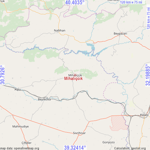
Mihalıçcık GPS coordinates[2]
39° 51' 57.384" North, 31° 29' 44.592" East
| Map corner | latitude | longitude |
|---|---|---|
| Upper-left | 40.4035°, | 30.7926° |
| Center: | 39.86594°, | 31.49572° |
| Lower-right: | 39.32414°, | 32.19885° |
| Map W x H: | 120×120 km | = 74.6×74.6mi |
| max Lat: | 42.02683° ⇑33.3% North |
| Mihalıçcık: | 39.86594° |
| min Lat: | ⇓66.7% South 35.9025° |
| min Long | Mihalıçcık | max Long |
| 25.90902° | 31.49572° | 44.60099° |
| W 31.2%⇐ | ⇒68.8% E |
Elevation
Elevation of Mihalıçcık is 1322 m = 4337 ft, and this is 604.6 m = 1984 ft above average elevation for this country.
| Max E: |
2682 m = 8799 ft | 14.4% |
| Mihalıçcık | 1322 m 4337 ft | |
| Avg. | 717.4 m = 2354 ft | |
Min E: |
0 m = 0 ft | 85.6% |
See also: Turkey elevation on elevation.city.
Geographical zone
Mihalıçcık is located in North temperate zone (between Tropic of Cancer and the Arctic Circle). Distance of this Northern Tropic circle is 1826.8 km =1135.1 mi to South.| Distance of | km | miles | from Mihalıçcık |
|---|---|---|---|
| North Pole | 5574.4 | 3463.8 | to North |
| Arctic Circle | 2968.5 | 1844.5 | to North |
| Tropic Cancer | 1826.8 | 1135.1 | to South |
| Equator | 4432.7 | 2754.4 | to South |


Nearby cities:
15 places around Mihalıçcık: (largest is in red/bold)
• Alpu
47 km =29.2 mi,  256°
256°
• Beylikova
31.8 km =19.8 mi,  231°
231°
• Beypazarı
49.4 km =30.7 mi,  47°
47°
• Bozan
34.7 km =21.6 mi, 255°
• Gelegra
33 km =20.5 mi,  60°
60°
• Günyüzü
60 km =37.3 mi,  153°
153°
• Karaşar
66 km =41 mi,  39°
39°
• Kaymaz
47.3 km =29.4 mi,  214°
214°
• Mahmudiye
59.7 km =37.1 mi, 226°
• Nallıhan
37.6 km =23.4 mi,  340°
340°
• Polatlı
63.9 km =39.7 mi,  120°
120°
• Seben
61 km =37.9 mi,  6°
6°
• Sivrihisar
46.3 km =28.8 mi,  175°
175°
• Çayırhan
29.9 km =18.6 mi,  30°
30°
• Çifteler
66.4 km =41.3 mi,  216°
216°
Sources, notices
• [Note1] Compared only with cities in Turkey existing in our database
• [Src1] Map data: © OpenStreetMap contributors (CC-BY-SA)
• [Src2] Other city data from geonames.org with taken over terms of usage.
• [Src3] Geographical zone / Annual Mean Temperature by Robert A. Rohde @ Wikipedia
