Nallıhan geodata
Nallıhan (Ankara) is a seat of a second-order administrative division; located in Turkey in Europe/Istanbul (GMT+3) time zone. With population of 19,106 people, there are 342 cities with bigger population in this country. Compared to other cities in Turkey, 72.2% of cities are located further ↓South; 69.3% of cities are located further →East and 53.1% of cities have higher elevation than Nallıhan. Note1


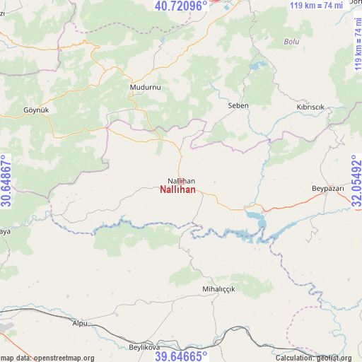
Nallıhan GPS coordinates[2]
40° 11' 9.348" North, 31° 21' 6.444" East
| Map corner | latitude | longitude |
|---|---|---|
| Upper-left | 40.72096°, | 30.64867° |
| Center: | 40.18593°, | 31.35179° |
| Lower-right: | 39.64665°, | 32.05492° |
| Map W x H: | 119.5×119.5 km | = 74.3×74.3mi |
| max Lat: | 42.02683° ⇑27.8% North |
| Nallıhan: | 40.18593° |
| min Lat: | ⇓72.2% South 35.9025° |
| min Long | Nallıhan | max Long |
| 25.90902° | 31.35179° | 44.60099° |
| W 30.7%⇐ | ⇒69.3% E |
Elevation
Elevation of Nallıhan is 630 m = 2067 ft, and this is 87.4 m = 287 ft below average elevation for this country.
| Max E: |
2682 m = 8799 ft | 53.1% |
| Avg. | 717.4 m = 2354 ft | |
| Nallıhan | 630 m = 2067 ft | |
Min E: |
0 m = 0 ft | 46.9% |
See also: Turkey elevation on elevation.city.
Geographical zone
Nallıhan is located in North temperate zone (between Tropic of Cancer and the Arctic Circle). Distance of this Northern Tropic circle is 1862.3 km =1157.2 mi to South.| Distance of | km | miles | from Nallıhan |
|---|---|---|---|
| North Pole | 5538.8 | 3441.6 | to North |
| Arctic Circle | 2932.9 | 1822.4 | to North |
| Tropic Cancer | 1862.3 | 1157.2 | to South |
| Equator | 4468.3 | 2776.5 | to South |


Nearby cities:
15 places around Nallıhan: (largest is in red/bold)
• Alpu
57.1 km =35.5 mi,  215°
215°
• Beylikova
56.9 km =35.4 mi,  192°
192°
• Beypazarı
48.4 km =30.1 mi,  92°
92°
• Bolu
64.8 km =40.3 mi,  19°
19°
• Bozan
49.1 km =30.5 mi,  205°
205°
• Dokurcun
59.5 km =37 mi,  316°
316°
• Gelegra
45.1 km =28 mi,  115°
115°
• Göynük
53.4 km =33.2 mi,  296°
296°
• Karaşar
56.1 km =34.9 mi,  73°
73°
• Kıbrıscık
49.1 km =30.5 mi,  59°
59°
• Mihalıçcık
37.6 km =23.4 mi,  160°
160°
• Mudurnu
34.2 km =21.3 mi,  339°
339°
• Sarıcakaya
63.8 km =39.6 mi,  254°
254°
• Seben
31.3 km =19.4 mi,  36°
36°
• Çayırhan
29 km =18 mi,  109°
109°
Sources, notices
• [Note1] Compared only with cities in Turkey existing in our database
• [Src1] Map data: © OpenStreetMap contributors (CC-BY-SA)
• [Src2] Other city data from geonames.org with taken over terms of usage.
• [Src3] Geographical zone / Annual Mean Temperature by Robert A. Rohde @ Wikipedia
