Aktaş geodata
Aktaş (Siirt) is a populated place; located in Turkey in Europe/Istanbul (GMT+3) time zone. With population of 501 people, there are 1320 cities with bigger population in this country. Compared to other cities in Turkey, 62.7% of cities are located further ↑North; 88.5% of cities are located further ←West and 53% of cities have higher elevation than Aktaş. Note1


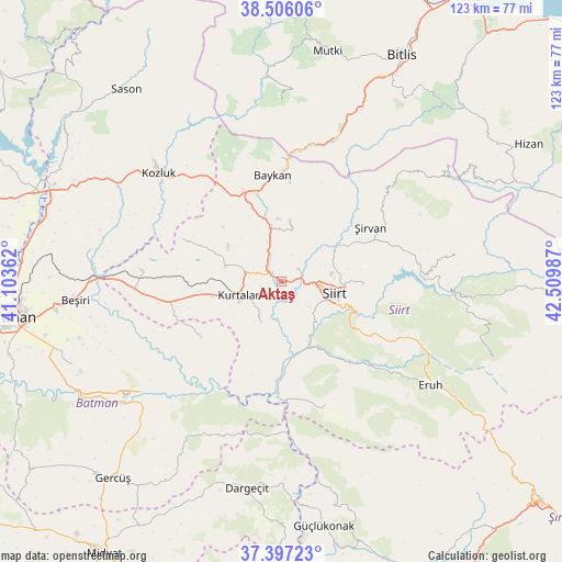
Aktaş GPS coordinates[2]
37° 57' 13.464" North, 41° 48' 24.264" East
| Map corner | latitude | longitude |
|---|---|---|
| Upper-left | 38.50606°, | 41.10362° |
| Center: | 37.95374°, | 41.80674° |
| Lower-right: | 37.39723°, | 42.50987° |
| Map W x H: | 123.3×123.3 km | = 76.6×76.6mi |
| max Lat: | 42.02683° ⇑62.7% North |
| Aktaş: | 37.95374° |
| min Lat: | ⇓37.3% South 35.9025° |
| min Long | Aktaş | max Long |
| 25.90902° | 41.80674° | 44.60099° |
| W 88.5%⇐ | ⇒11.5% E |
Elevation
Elevation of Aktaş is 633 m = 2077 ft, and this is 84.4 m = 277 ft below average elevation for this country.
| Max E: |
2682 m = 8799 ft | 53% |
| Avg. | 717.4 m = 2354 ft | |
| Aktaş | 633 m = 2077 ft | |
Min E: |
0 m = 0 ft | 47% |
See also: Turkey elevation on elevation.city.
Geographical zone
Aktaş is located in North temperate zone (between Tropic of Cancer and the Arctic Circle). Distance of this Northern Tropic circle is 1614.1 km =1003 mi to South.| Distance of | km | miles | from Aktaş |
|---|---|---|---|
| North Pole | 5787 | 3595.9 | to North |
| Arctic Circle | 3181.1 | 1976.6 | to North |
| Tropic Cancer | 1614.1 | 1003 | to South |
| Equator | 4220.1 | 2622.2 | to South |


Nearby cities:
15 places around Aktaş: (largest is in red/bold)
• Baykan
22.8 km =14.2 mi,  352°
352°
• Bağlıca
10.5 km =6.5 mi,  207°
207°
• Beykent
13.1 km =8.1 mi,  233°
233°
• Beşpınar
22.1 km =13.7 mi, 234°
• Civankan
8.4 km =5.2 mi,  132°
132°
• Dilektepe
13.6 km =8.5 mi,  7°
7°
• Doluharman
10.2 km =6.3 mi,  69°
69°
• Erdurağı
21 km =13 mi,  253°
253°
• Kayabağlar
12.7 km =7.9 mi,  286°
286°
• Konakpınar
15.7 km =9.8 mi,  257°
257°
• Kurtalan
11.1 km =6.9 mi, 253°
• Siirt
12.1 km =7.5 mi,  102°
102°
• Tillo
18 km =11.2 mi,  91°
91°
• İkizbağlar
14.9 km =9.3 mi,  79°
79°
• Şirvan
22.6 km =14 mi,  57°
57°
Sources, notices
• [Note1] Compared only with cities in Turkey existing in our database
• [Src1] Map data: © OpenStreetMap contributors (CC-BY-SA)
• [Src2] Other city data from geonames.org with taken over terms of usage.
• [Src3] Geographical zone / Annual Mean Temperature by Robert A. Rohde @ Wikipedia
