Dağlıca geodata
Dağlıca (Hakkâri) is a seat of a third-order administrative division; located in Turkey in Europe/Istanbul (GMT+3) time zone. In our database, there are 1323 cities with bigger population. Compared to other cities in Turkey, 78.6% of cities are located further ↑North; 99.7% of cities are located further ←West and 91.6% of cities have lower elevation than Dağlıca. Note1


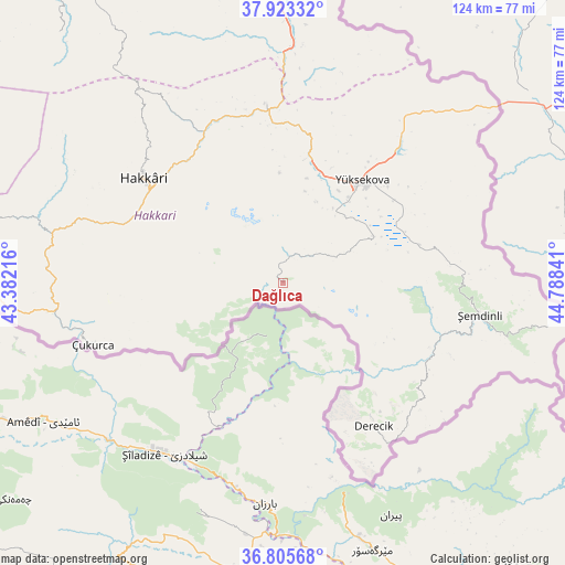
Dağlıca GPS coordinates[2]
37° 21' 59.688" North, 44° 5' 7.008" East
| Map corner | latitude | longitude |
|---|---|---|
| Upper-left | 37.92332°, | 43.38216° |
| Center: | 37.36658°, | 44.08528° |
| Lower-right: | 36.80568°, | 44.78841° |
| Map W x H: | 124.3×124.3 km | = 77.2×77.2mi |
| max Lat: | 42.02683° ⇑78.6% North |
| Dağlıca: | 37.36658° |
| min Lat: | ⇓21.4% South 35.9025° |
| min Long | Dağlıca | max Long |
| 25.90902° | 44.08528° | 44.60099° |
| W 99.7%⇐ | ⇒0.3% E |
Elevation
Elevation of Dağlıca is 1527 m = 5010 ft, and this is 809.6 m = 2656 ft above average elevation for this country.
| Max E: |
2682 m = 8799 ft | 8.4% |
| Dağlıca | 1527 m 5010 ft | |
| Avg. | 717.4 m = 2354 ft | |
Min E: |
0 m = 0 ft | 91.6% |
See also: Turkey elevation on elevation.city.
Geographical zone
Dağlıca is located in North temperate zone (between Tropic of Cancer and the Arctic Circle). Distance of this Northern Tropic circle is 1548.9 km =962.4 mi to South.| Distance of | km | miles | from Dağlıca |
|---|---|---|---|
| North Pole | 5852.3 | 3636.4 | to North |
| Arctic Circle | 3246.4 | 2017.2 | to North |
| Tropic Cancer | 1548.9 | 962.4 | to South |
| Equator | 4154.8 | 2581.7 | to South |


Nearby cities:
15 places around Dağlıca: (largest is in red/bold)
• Andaç
72.6 km =45.1 mi,  268°
268°
• Ashuta
63 km =39.1 mi, 265°
• Başkale
75.7 km =47 mi,  355°
355°
• Esendere
59.5 km =37 mi,  49°
49°
• Geçitli
52.3 km =32.5 mi,  297°
297°
• Hakkâri
38.2 km =23.7 mi,  307°
307°
• Hazekyan
39.3 km =24.4 mi,  353°
353°
• Karsani
56.2 km =34.9 mi,  263°
263°
• Kelitan
55.7 km =34.6 mi, 274°
• Ortaköy
71 km =44.1 mi, 266°
• Oymakaya
75.7 km =47 mi, 274°
• Yalınca
73.7 km =45.8 mi,  317°
317°
• Yüksekova
29.1 km =18.1 mi,  37°
37°
• Çukurca
43.7 km =27.2 mi,  252°
252°
• Şemdinli
43.8 km =27.2 mi,  98°
98°
Sources, notices
• [Note1] Compared only with cities in Turkey existing in our database
• [Src1] Map data: © OpenStreetMap contributors (CC-BY-SA)
• [Src2] Other city data from geonames.org with taken over terms of usage.
• [Src3] Geographical zone / Annual Mean Temperature by Robert A. Rohde @ Wikipedia
