Yüksekova geodata
Yüksekova (Hakkâri) is a seat of a second-order administrative division; located in Turkey in Europe/Istanbul (GMT+3) time zone. With population of 71,729 people, there are 127 cities with bigger population in this country. Compared to other cities in Turkey, 72.9% of cities are located further ↑North; 99.9% of cities are located further ←West and 98.1% of cities have lower elevation than Yüksekova. Note1


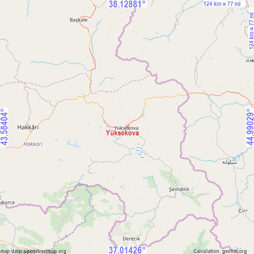
Yüksekova GPS coordinates[2]
37° 34' 25.032" North, 44° 17' 13.776" East
| Map corner | latitude | longitude |
|---|---|---|
| Upper-left | 38.12881°, | 43.58404° |
| Center: | 37.57362°, | 44.28716° |
| Lower-right: | 37.01426°, | 44.99029° |
| Map W x H: | 123.9×123.9 km | = 77×77mi |
| max Lat: | 42.02683° ⇑72.9% North |
| Yüksekova: | 37.57362° |
| min Lat: | ⇓27.1% South 35.9025° |
| min Long | Yüksekova | max Long |
| 25.90902° | 44.28716° | 44.60099° |
| W 99.9%⇐ | ⇒0.099999999999994% E |
Elevation
Elevation of Yüksekova is 1874 m = 6148 ft, and this is 1156.6 m = 3795 ft above average elevation for this country.
| Max E: |
2682 m = 8799 ft | 1.9% |
| Yüksekova | 1874 m 6148 ft | |
| Avg. | 717.4 m = 2354 ft | |
Min E: |
0 m = 0 ft | 98.1% |
See also: Yüksekova elevation on elevation.city.
Geographical zone
Yüksekova is located in North temperate zone (between Tropic of Cancer and the Arctic Circle). Distance of this Northern Tropic circle is 1571.9 km =976.7 mi to South.| Distance of | km | miles | from Yüksekova |
|---|---|---|---|
| North Pole | 5829.3 | 3622.2 | to North |
| Arctic Circle | 3223.4 | 2002.9 | to North |
| Tropic Cancer | 1571.9 | 976.7 | to South |
| Equator | 4177.8 | 2596 | to South |


Nearby cities:
15 places around Yüksekova: (largest is in red/bold)
• Albayrak
63.7 km =39.6 mi,  353°
353°
• Ashuta
85.2 km =52.9 mi,  250°
250°
• Başkale
57.6 km =35.8 mi,  335°
335°
• Dağlıca
29.1 km =18.1 mi,  217°
217°
• Esendere
31.6 km =19.6 mi,  60°
60°
• Geçitli
63.9 km =39.7 mi,  271°
271°
• Güzelsu
92.4 km =57.4 mi,  332°
332°
• Hakkâri
48.1 km =29.9 mi, 270°
• Hazekyan
27.3 km =17 mi,  305°
305°
• Karsani
79.3 km =49.3 mi, 248°
• Kelitan
75.5 km =46.9 mi,  255°
255°
• Ortaköy
92.7 km =57.6 mi, 252°
• Yalınca
74.3 km =46.2 mi,  295°
295°
• Çukurca
69.6 km =43.2 mi,  238°
238°
• Şemdinli
39.2 km =24.4 mi,  139°
139°
Sources, notices
• [Note1] Compared only with cities in Turkey existing in our database
• [Src1] Map data: © OpenStreetMap contributors (CC-BY-SA)
• [Src2] Other city data from geonames.org with taken over terms of usage.
• [Src3] Geographical zone / Annual Mean Temperature by Robert A. Rohde @ Wikipedia
