Akcakışla geodata
Akcakışla (Sivas) is a seat of a third-order administrative division; located in Turkey in Europe/Istanbul (GMT+3) time zone. In our database, there are 1323 cities with bigger population. Compared to other cities in Turkey, 61.7% of cities are located further ↓South; 53.7% of cities are located further ←West and 83% of cities have lower elevation than Akcakışla. Note1


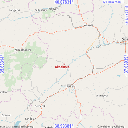
Akcakışla GPS coordinates[2]
39° 32' 17.448" North, 36° 20' 10.536" East
| Map corner | latitude | longitude |
|---|---|---|
| Upper-left | 40.07831°, | 35.63314° |
| Center: | 39.53818°, | 36.33626° |
| Lower-right: | 38.99381°, | 37.03939° |
| Map W x H: | 120.6×120.6 km | = 74.9×74.9mi |
| max Lat: | 42.02683° ⇑38.3% North |
| Akcakışla: | 39.53818° |
| min Lat: | ⇓61.7% South 35.9025° |
| min Long | Akcakışla | max Long |
| 25.90902° | 36.33626° | 44.60099° |
| W 53.7%⇐ | ⇒46.3% E |
Elevation
Elevation of Akcakışla is 1265 m = 4150 ft, and this is 547.6 m = 1797 ft above average elevation for this country.
| Max E: |
2682 m = 8799 ft | 17% |
| Akcakışla | 1265 m 4150 ft | |
| Avg. | 717.4 m = 2354 ft | |
Min E: |
0 m = 0 ft | 83% |
See also: Turkey elevation on elevation.city.
Geographical zone
Akcakışla is located in North temperate zone (between Tropic of Cancer and the Arctic Circle). Distance of this Northern Tropic circle is 1790.3 km =1112.4 mi to South.| Distance of | km | miles | from Akcakışla |
|---|---|---|---|
| North Pole | 5610.8 | 3486.4 | to North |
| Arctic Circle | 3004.9 | 1867.2 | to North |
| Tropic Cancer | 1790.3 | 1112.4 | to South |
| Equator | 4396.2 | 2731.7 | to South |


Nearby cities:
15 places around Akcakışla: (largest is in red/bold)
• Akdağmadeni
41.1 km =25.5 mi,  289°
289°
• Akkışla
61.2 km =38 mi,  193°
193°
• Altınyayla
46.3 km =28.8 mi,  129°
129°
• Bedirli
24.9 km =15.5 mi,  78°
78°
• Direkli
33.2 km =20.6 mi,  54°
54°
• Gemerek
45.5 km =28.3 mi,  209°
209°
• Kayadibi
32.9 km =20.4 mi,  101°
101°
• Ortaköy
15.7 km =9.8 mi, 214°
• Sarıoğlan
60.3 km =37.5 mi, 211°
• Sulusaray
55.1 km =34.2 mi,  336°
336°
• Ulaş
61.2 km =38 mi, 99°
• Yavu
30.3 km =18.8 mi, 338°
• Yeşilyurt
53 km =32.9 mi,  349°
349°
• Yıldızeli
42.9 km =26.7 mi,  31°
31°
• Şarkışla
21.7 km =13.5 mi,  163°
163°
Sources, notices
• [Note1] Compared only with cities in Turkey existing in our database
• [Src1] Map data: © OpenStreetMap contributors (CC-BY-SA)
• [Src2] Other city data from geonames.org with taken over terms of usage.
• [Src3] Geographical zone / Annual Mean Temperature by Robert A. Rohde @ Wikipedia
