Şarkışla geodata
Şarkışla (Sivas) is a seat of a second-order administrative division; located in Turkey in Europe/Istanbul (GMT+3) time zone. With population of 23,800 people, there are 299 cities with bigger population in this country. Compared to other cities in Turkey, 59.5% of cities are located further ↓South; 54.1% of cities are located further ←West and 82.7% of cities have lower elevation than Şarkışla. Note1


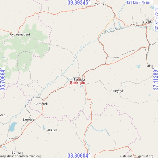
Şarkışla GPS coordinates[2]
39° 21' 6.696" North, 36° 24' 35.136" East
| Map corner | latitude | longitude |
|---|---|---|
| Upper-left | 39.89345°, | 35.70664° |
| Center: | 39.35186°, | 36.40976° |
| Lower-right: | 38.80604°, | 37.11289° |
| Map W x H: | 120.9×120.9 km | = 75.1×75.1mi |
| max Lat: | 42.02683° ⇑40.5% North |
| Şarkışla: | 39.35186° |
| min Lat: | ⇓59.5% South 35.9025° |
| min Long | Şarkışla | max Long |
| 25.90902° | 36.40976° | 44.60099° |
| W 54.1%⇐ | ⇒45.9% E |
Elevation
Elevation of Şarkışla is 1250 m = 4101 ft, and this is 532.6 m = 1747 ft above average elevation for this country.
| Max E: |
2682 m = 8799 ft | 17.3% |
| Şarkışla | 1250 m 4101 ft | |
| Avg. | 717.4 m = 2354 ft | |
Min E: |
0 m = 0 ft | 82.7% |
See also: Turkey elevation on elevation.city.
Geographical zone
Şarkışla is located in North temperate zone (between Tropic of Cancer and the Arctic Circle). Distance of this Northern Tropic circle is 1769.6 km =1099.6 mi to South.| Distance of | km | miles | from Şarkışla |
|---|---|---|---|
| North Pole | 5631.5 | 3499.3 | to North |
| Arctic Circle | 3025.7 | 1880.1 | to North |
| Tropic Cancer | 1769.6 | 1099.6 | to South |
| Equator | 4375.5 | 2718.8 | to South |


Nearby cities:
15 places around Şarkışla: (largest is in red/bold)
• Akcakışla
21.7 km =13.5 mi,  343°
343°
• Akdağmadeni
56.7 km =35.2 mi,  307°
307°
• Akkışla
43.9 km =27.3 mi,  207°
207°
• Altınyayla
30.7 km =19.1 mi,  106°
106°
• Bedirli
31.4 km =19.5 mi,  35°
35°
• Direkli
45.1 km =28 mi,  27°
27°
• Gemerek
34.6 km =21.5 mi,  237°
237°
• Kayadibi
29.6 km =18.4 mi,  61°
61°
• Kaynar
50.5 km =31.4 mi,  175°
175°
• Ortaköy
17 km =10.6 mi,  297°
297°
• Sarıoğlan
48.9 km =30.4 mi,  231°
231°
• Ulaş
55 km =34.2 mi,  79°
79°
• Yavu
52 km =32.3 mi, 340°
• Yıldızeli
59.5 km =37 mi,  15°
15°
• Örenşehir
44.4 km =27.6 mi,  152°
152°
Sources, notices
• [Note1] Compared only with cities in Turkey existing in our database
• [Src1] Map data: © OpenStreetMap contributors (CC-BY-SA)
• [Src2] Other city data from geonames.org with taken over terms of usage.
• [Src3] Geographical zone / Annual Mean Temperature by Robert A. Rohde @ Wikipedia
