Akkışla geodata
Akkışla (Kayseri) is a seat of a second-order administrative division; located in Turkey in Europe/Istanbul (GMT+3) time zone. With population of 3,317 people, there are 835 cities with bigger population in this country. Compared to other cities in Turkey, 54.5% of cities are located further ↓South; 51.9% of cities are located further ←West and 87.1% of cities have lower elevation than Akkışla. Note1


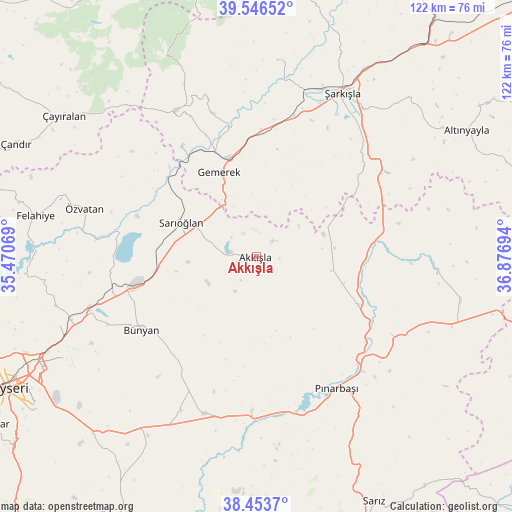
Akkışla GPS coordinates[2]
39° 0' 7.992" North, 36° 10' 25.716" East
| Map corner | latitude | longitude |
|---|---|---|
| Upper-left | 39.54652°, | 35.47069° |
| Center: | 39.00222°, | 36.17381° |
| Lower-right: | 38.4537°, | 36.87694° |
| Map W x H: | 121.5×121.5 km | = 75.5×75.5mi |
| max Lat: | 42.02683° ⇑45.5% North |
| Akkışla: | 39.00222° |
| min Lat: | ⇓54.5% South 35.9025° |
| min Long | Akkışla | max Long |
| 25.90902° | 36.17381° | 44.60099° |
| W 51.9%⇐ | ⇒48.1% E |
Elevation
Elevation of Akkışla is 1370 m = 4495 ft, and this is 652.6 m = 2141 ft above average elevation for this country.
| Max E: |
2682 m = 8799 ft | 12.9% |
| Akkışla | 1370 m 4495 ft | |
| Avg. | 717.4 m = 2354 ft | |
Min E: |
0 m = 0 ft | 87.1% |
See also: Turkey elevation on elevation.city.
Geographical zone
Akkışla is located in North temperate zone (between Tropic of Cancer and the Arctic Circle). Distance of this Northern Tropic circle is 1730.7 km =1075.4 mi to South.| Distance of | km | miles | from Akkışla |
|---|---|---|---|
| North Pole | 5670.4 | 3523.4 | to North |
| Arctic Circle | 3064.5 | 1904.2 | to North |
| Tropic Cancer | 1730.7 | 1075.4 | to South |
| Equator | 4336.6 | 2694.6 | to South |


Nearby cities:
15 places around Akkışla: (largest is in red/bold)
• Bünyan
32.2 km =20 mi,  237°
237°
• Elbaşı
40.7 km =25.3 mi,  206°
206°
• Felahiye
53.3 km =33.1 mi,  280°
280°
• Gemerek
22 km =13.7 mi,  336°
336°
• Gesi
50.3 km =31.3 mi, 242°
• Kaynar
26.8 km =16.7 mi,  115°
115°
• Muncusun
48.5 km =30.1 mi,  256°
256°
• Ortaköy
46.9 km =29.1 mi,  6°
6°
• Pazarören
36.5 km =22.7 mi,  181°
181°
• Pınarbaşı
36.4 km =22.6 mi,  148°
148°
• Sarıoğlan
19.7 km =12.2 mi,  294°
294°
• Çayıralan
56.6 km =35.2 mi,  306°
306°
• Örenşehir
41.1 km =25.5 mi,  90°
90°
• Özvatan
42.5 km =26.4 mi, 285°
• Şarkışla
43.9 km =27.3 mi,  27°
27°
Sources, notices
• [Note1] Compared only with cities in Turkey existing in our database
• [Src1] Map data: © OpenStreetMap contributors (CC-BY-SA)
• [Src2] Other city data from geonames.org with taken over terms of usage.
• [Src3] Geographical zone / Annual Mean Temperature by Robert A. Rohde @ Wikipedia
