Beyağaç geodata
Beyağaç (Denizli) is a seat of a second-order administrative division; located in Turkey in Europe/Istanbul (GMT+3) time zone. In our database, there are 1323 cities with bigger population. Compared to other cities in Turkey, 82.2% of cities are located further ↑North; 84.7% of cities are located further →East and 50.3% of cities have lower elevation than Beyağaç. Note1


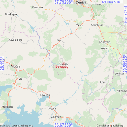
Beyağaç GPS coordinates[2]
37° 14' 6.936" North, 28° 53' 46.032" East
| Map corner | latitude | longitude |
|---|---|---|
| Upper-left | 37.79298°, | 28.193° |
| Center: | 37.23526°, | 28.89612° |
| Lower-right: | 36.67339°, | 29.59925° |
| Map W x H: | 124.5×124.5 km | = 77.4×77.4mi |
| max Lat: | 42.02683° ⇑82.2% North |
| Beyağaç: | 37.23526° |
| min Lat: | ⇓17.8% South 35.9025° |
| min Long | Beyağaç | max Long |
| 25.90902° | 28.89612° | 44.60099° |
| W 15.3%⇐ | ⇒84.7% E |
Elevation
Elevation of Beyağaç is 697 m = 2287 ft, and this is 20.4 m = 67 ft below average elevation for this country.
| Max E: |
2682 m = 8799 ft | 49.7% |
| Avg. | 717.4 m = 2354 ft | |
| Beyağaç | 697 m = 2287 ft | |
Min E: |
0 m = 0 ft | 50.3% |
See also: Turkey elevation on elevation.city.
Geographical zone
Beyağaç is located in North temperate zone (between Tropic of Cancer and the Arctic Circle). Distance of this Northern Tropic circle is 1534.3 km =953.4 mi to South.| Distance of | km | miles | from Beyağaç |
|---|---|---|---|
| North Pole | 5866.9 | 3645.5 | to North |
| Arctic Circle | 3261 | 2026.3 | to North |
| Tropic Cancer | 1534.3 | 953.4 | to South |
| Equator | 4140.2 | 2572.6 | to South |


Nearby cities:
15 places around Beyağaç: (largest is in red/bold)
• Acıpayam
45.2 km =28.1 mi,  62°
62°
• Dalaman
52.8 km =32.8 mi,  189°
189°
• Dalyan
49.9 km =31 mi,  206°
206°
• Göktepe
36.1 km =22.4 mi,  304°
304°
• Kale
23.1 km =14.4 mi,  348°
348°
• Kavaklıdere
52.6 km =32.7 mi, 296°
• Kelekçi
36.1 km =22.4 mi,  89°
89°
• Kızılcabölük
43.2 km =26.8 mi,  14°
14°
• Muğla
46.9 km =29.1 mi,  267°
267°
• Nikfer
28.5 km =17.7 mi,  48°
48°
• Ortaca
45.6 km =28.3 mi, 194°
• Serinhisar
50.5 km =31.4 mi,  40°
40°
• Tavas
40.6 km =25.2 mi,  22°
22°
• Ula
44.9 km =27.9 mi,  251°
251°
• Çameli
43.5 km =27 mi,  113°
113°
Sources, notices
• [Note1] Compared only with cities in Turkey existing in our database
• [Src1] Map data: © OpenStreetMap contributors (CC-BY-SA)
• [Src2] Other city data from geonames.org with taken over terms of usage.
• [Src3] Geographical zone / Annual Mean Temperature by Robert A. Rohde @ Wikipedia
