Vezirhan geodata
Vezirhan (Bilecik) is a populated place; located in Turkey in Europe/Istanbul (GMT+3) time zone. With population of 3,123 people, there are 852 cities with bigger population in this country. Compared to other cities in Turkey, 73.5% of cities are located further ↓South; 75.5% of cities are located further →East and 76% of cities have higher elevation than Vezirhan. Note1


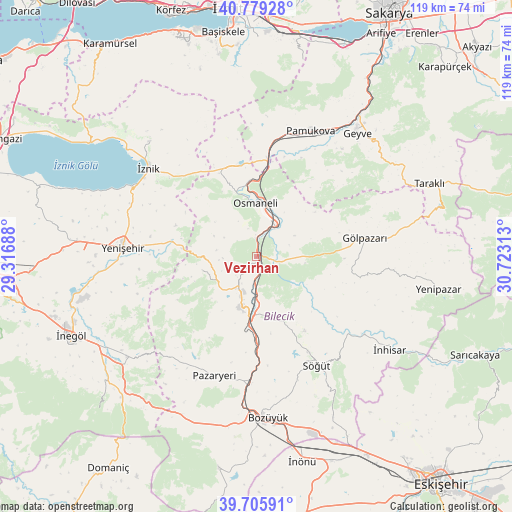
Vezirhan GPS coordinates[2]
40° 14' 40.992" North, 30° 1' 12" East
| Map corner | latitude | longitude |
|---|---|---|
| Upper-left | 40.77928°, | 29.31688° |
| Center: | 40.24472°, | 30.02° |
| Lower-right: | 39.70591°, | 30.72313° |
| Map W x H: | 119.3×119.3 km | = 74.1×74.1mi |
| max Lat: | 42.02683° ⇑26.5% North |
| Vezirhan: | 40.24472° |
| min Lat: | ⇓73.5% South 35.9025° |
| min Long | Vezirhan | max Long |
| 25.90902° | 30.02° | 44.60099° |
| W 24.5%⇐ | ⇒75.5% E |
Elevation
Elevation of Vezirhan is 163 m = 535 ft, and this is 554.4 m = 1819 ft below average elevation for this country.
| Max E: |
2682 m = 8799 ft | 76% |
| Avg. | 717.4 m = 2354 ft | |
| Vezirhan | 163 m = 535 ft | |
Min E: |
0 m = 0 ft | 24% |
See also: Turkey elevation on elevation.city.
Geographical zone
Vezirhan is located in North temperate zone (between Tropic of Cancer and the Arctic Circle). Distance of this Northern Tropic circle is 1868.9 km =1161.3 mi to South.| Distance of | km | miles | from Vezirhan |
|---|---|---|---|
| North Pole | 5532.3 | 3437.6 | to North |
| Arctic Circle | 2926.4 | 1818.4 | to North |
| Tropic Cancer | 1868.9 | 1161.3 | to South |
| Equator | 4474.8 | 2780.5 | to South |


Nearby cities:
15 places around Vezirhan: (largest is in red/bold)
• Bilecik
11.9 km =7.4 mi,  196°
196°
• Dırazali
31.4 km =19.5 mi,  302°
302°
• Elbeyli
36.7 km =22.8 mi,  317°
317°
• Elmalı
32.3 km =20.1 mi,  338°
338°
• Gölpazarı
25.6 km =15.9 mi,  79°
79°
• Kaynarca
25.1 km =15.6 mi, 318°
• Küplü
16.4 km =10.2 mi,  185°
185°
• Osmaneli
12.5 km =7.8 mi,  357°
357°
• Pamukova
31.8 km =19.8 mi,  23°
23°
• Pazaryeri
29.6 km =18.4 mi, 199°
• Sansarak
31.6 km =19.6 mi,  329°
329°
• Söğüt
29.2 km =18.1 mi,  151°
151°
• Yarhisar
13 km =8.1 mi,  256°
256°
• Yenişehir
31.2 km =19.4 mi,  274°
274°
• İznik
32.6 km =20.3 mi,  308°
308°
Sources, notices
• [Note1] Compared only with cities in Turkey existing in our database
• [Src1] Map data: © OpenStreetMap contributors (CC-BY-SA)
• [Src2] Other city data from geonames.org with taken over terms of usage.
• [Src3] Geographical zone / Annual Mean Temperature by Robert A. Rohde @ Wikipedia
