Kaynarca geodata
Kaynarca (Bursa) is a populated place; located in Turkey in Europe/Istanbul (GMT+3) time zone. With population of 863 people, there are 1128 cities with bigger population in this country. Compared to other cities in Turkey, 76.4% of cities are located further ↓South; 77% of cities are located further →East and 72.4% of cities have higher elevation than Kaynarca. Note1


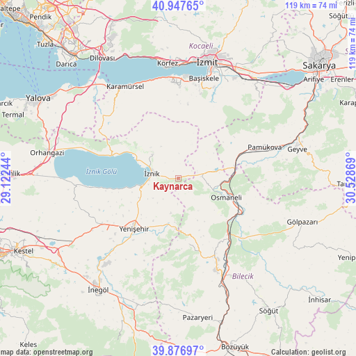
Kaynarca GPS coordinates[2]
40° 24' 51.984" North, 29° 49' 32.016" East
| Map corner | latitude | longitude |
|---|---|---|
| Upper-left | 40.94765°, | 29.12244° |
| Center: | 40.41444°, | 29.82556° |
| Lower-right: | 39.87697°, | 30.52869° |
| Map W x H: | 119×119 km | = 73.9×73.9mi |
| max Lat: | 42.02683° ⇑23.6% North |
| Kaynarca: | 40.41444° |
| min Lat: | ⇓76.4% South 35.9025° |
| min Long | Kaynarca | max Long |
| 25.90902° | 29.82556° | 44.60099° |
| W 23%⇐ | ⇒77% E |
Elevation
Elevation of Kaynarca is 227 m = 745 ft, and this is 490.4 m = 1609 ft below average elevation for this country.
| Max E: |
2682 m = 8799 ft | 72.4% |
| Avg. | 717.4 m = 2354 ft | |
| Kaynarca | 227 m = 745 ft | |
Min E: |
0 m = 0 ft | 27.6% |
See also: Turkey elevation on elevation.city.
Geographical zone
Kaynarca is located in North temperate zone (between Tropic of Cancer and the Arctic Circle). Distance of this Northern Tropic circle is 1887.7 km =1173 mi to South.| Distance of | km | miles | from Kaynarca |
|---|---|---|---|
| North Pole | 5513.4 | 3425.9 | to North |
| Arctic Circle | 2907.5 | 1806.6 | to North |
| Tropic Cancer | 1887.7 | 1173 | to South |
| Equator | 4493.7 | 2792.3 | to South |


Nearby cities:
15 places around Kaynarca: (largest is in red/bold)
• Balarim
20.4 km =12.7 mi,  257°
257°
• Boyalıca
23.6 km =14.7 mi,  288°
288°
• Dırazali
10.2 km =6.3 mi, 258°
• Elbeyli
11.7 km =7.3 mi,  313°
313°
• Elmalı
12.2 km =7.6 mi,  22°
22°
• Nüzhetiye
25.3 km =15.7 mi,  7°
7°
• Orhaniye
17.3 km =10.7 mi, 305°
• Osmaneli
17.2 km =10.7 mi,  111°
111°
• Sansarak
8.3 km =5.2 mi,  2°
2°
• Tacir
14.3 km =8.9 mi,  329°
329°
• Vezirhan
25.1 km =15.6 mi,  138°
138°
• Yarhisar
22.3 km =13.9 mi,  170°
170°
• Yenişehir
22.2 km =13.8 mi,  221°
221°
• Çakırca
15.1 km =9.4 mi, 294°
• İznik
9 km =5.6 mi,  280°
280°
Sources, notices
• [Note1] Compared only with cities in Turkey existing in our database
• [Src1] Map data: © OpenStreetMap contributors (CC-BY-SA)
• [Src2] Other city data from geonames.org with taken over terms of usage.
• [Src3] Geographical zone / Annual Mean Temperature by Robert A. Rohde @ Wikipedia
