Çayırhan geodata
Çayırhan (Ankara) is a seat of a third-order administrative division; located in Turkey in Europe/Istanbul (GMT+3) time zone. In our database, there are 1323 cities with bigger population. Compared to other cities in Turkey, 70.9% of cities are located further ↓South; 68.2% of cities are located further →East and 61% of cities have higher elevation than Çayırhan. Note1


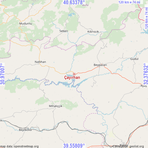
Çayırhan GPS coordinates[2]
40° 5' 53.016" North, 31° 40' 23.484" East
| Map corner | latitude | longitude |
|---|---|---|
| Upper-left | 40.63378°, | 30.97007° |
| Center: | 40.09806°, | 31.67319° |
| Lower-right: | 39.55809°, | 32.37632° |
| Map W x H: | 119.6×119.6 km | = 74.3×74.3mi |
| max Lat: | 42.02683° ⇑29.1% North |
| Çayırhan: | 40.09806° |
| min Lat: | ⇓70.9% South 35.9025° |
| min Long | Çayırhan | max Long |
| 25.90902° | 31.67319° | 44.60099° |
| W 31.8%⇐ | ⇒68.2% E |
Elevation
Elevation of Çayırhan is 493 m = 1617 ft, and this is 224.4 m = 736 ft below average elevation for this country.
| Max E: |
2682 m = 8799 ft | 61% |
| Avg. | 717.4 m = 2354 ft | |
| Çayırhan | 493 m = 1617 ft | |
Min E: |
0 m = 0 ft | 39% |
See also: Turkey elevation on elevation.city.
Geographical zone
Çayırhan is located in North temperate zone (between Tropic of Cancer and the Arctic Circle). Distance of this Northern Tropic circle is 1852.6 km =1151.2 mi to South.| Distance of | km | miles | from Çayırhan |
|---|---|---|---|
| North Pole | 5548.6 | 3447.7 | to North |
| Arctic Circle | 2942.7 | 1828.5 | to North |
| Tropic Cancer | 1852.6 | 1151.2 | to South |
| Equator | 4458.5 | 2770.4 | to South |


Nearby cities:
15 places around Çayırhan: (largest is in red/bold)
• Ayaş
56.8 km =35.3 mi,  98°
98°
• Beylikova
60.7 km =37.7 mi,  221°
221°
• Beypazarı
22.4 km =13.9 mi,  69°
69°
• Bozan
59.7 km =37.1 mi,  234°
234°
• Gelegra
16.4 km =10.2 mi,  124°
124°
• Güdül
50.2 km =31.2 mi,  75°
75°
• Karaşar
36.7 km =22.8 mi,  46°
46°
• Kıbrıscık
37.6 km =23.4 mi,  23°
23°
• Mihalıçcık
29.9 km =18.6 mi,  210°
210°
• Mudurnu
57.4 km =35.7 mi,  316°
316°
• Nallıhan
29 km =18 mi,  289°
289°
• Peçenek
64.6 km =40.1 mi,  56°
56°
• Polatlı
70.4 km =43.7 mi,  145°
145°
• Seben
35.8 km =22.2 mi,  346°
346°
• Uruş
42.9 km =26.7 mi, 66°
Sources, notices
• [Note1] Compared only with cities in Turkey existing in our database
• [Src1] Map data: © OpenStreetMap contributors (CC-BY-SA)
• [Src2] Other city data from geonames.org with taken over terms of usage.
• [Src3] Geographical zone / Annual Mean Temperature by Robert A. Rohde @ Wikipedia
