Seben geodata
Seben (Bolu) is a seat of a second-order administrative division; located in Turkey in Europe/Istanbul (GMT+3) time zone. With population of 4,375 people, there are 760 cities with bigger population in this country. Compared to other cities in Turkey, 76.3% of cities are located further ↓South; 68.5% of cities are located further →East and 53.5% of cities have lower elevation than Seben. Note1


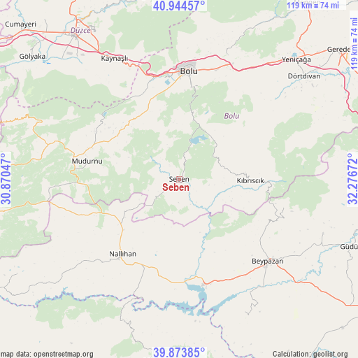
Seben GPS coordinates[2]
40° 24' 40.824" North, 31° 34' 24.924" East
| Map corner | latitude | longitude |
|---|---|---|
| Upper-left | 40.94457°, | 30.87047° |
| Center: | 40.41134°, | 31.57359° |
| Lower-right: | 39.87385°, | 32.27672° |
| Map W x H: | 119.1×119.1 km | = 74×74mi |
| max Lat: | 42.02683° ⇑23.7% North |
| Seben: | 40.41134° |
| min Lat: | ⇓76.3% South 35.9025° |
| min Long | Seben | max Long |
| 25.90902° | 31.57359° | 44.60099° |
| W 31.5%⇐ | ⇒68.5% E |
Elevation
Elevation of Seben is 767 m = 2516 ft, and this is 49.6 m = 163 ft above average elevation for this country.
| Max E: |
2682 m = 8799 ft | 46.5% |
| Seben | 767 m 2516 ft | |
| Avg. | 717.4 m = 2354 ft | |
Min E: |
0 m = 0 ft | 53.5% |
See also: Turkey elevation on elevation.city.
Geographical zone
Seben is located in North temperate zone (between Tropic of Cancer and the Arctic Circle). Distance of this Northern Tropic circle is 1887.4 km =1172.8 mi to South.| Distance of | km | miles | from Seben |
|---|---|---|---|
| North Pole | 5513.7 | 3426.1 | to North |
| Arctic Circle | 2907.9 | 1806.9 | to North |
| Tropic Cancer | 1887.4 | 1172.8 | to South |
| Equator | 4493.3 | 2792 | to South |


Nearby cities:
15 places around Seben: (largest is in red/bold)
• Beypazarı
40 km =24.9 mi,  132°
132°
• Bolu
36.2 km =22.5 mi,  4°
4°
• Dörtdivan
53.8 km =33.4 mi,  50°
50°
• Düzce
58.8 km =36.5 mi,  323°
323°
• Gelegra
49.3 km =30.6 mi,  153°
153°
• Güdül
61.2 km =38 mi,  111°
111°
• Karaşar
36.3 km =22.6 mi, 105°
• Kaynaşlı
45.1 km =28 mi,  331°
331°
• Kıbrıscık
23.6 km =14.7 mi,  90°
90°
• Mihalıçcık
61 km =37.9 mi,  186°
186°
• Mudurnu
31.7 km =19.7 mi,  282°
282°
• Nallıhan
31.3 km =19.4 mi,  216°
216°
• Uruş
51.1 km =31.8 mi, 110°
• Yeniçağa
55.8 km =34.7 mi,  44°
44°
• Çayırhan
35.8 km =22.2 mi,  166°
166°
Sources, notices
• [Note1] Compared only with cities in Turkey existing in our database
• [Src1] Map data: © OpenStreetMap contributors (CC-BY-SA)
• [Src2] Other city data from geonames.org with taken over terms of usage.
• [Src3] Geographical zone / Annual Mean Temperature by Robert A. Rohde @ Wikipedia
