Gülyalı geodata
Gülyalı (Ordu) is a seat of a second-order administrative division; located in Turkey in Europe/Istanbul (GMT+3) time zone. In our database, there are 1323 cities with bigger population. Compared to other cities in Turkey, 88.1% of cities are located further ↓South; 61.9% of cities are located further ←West and 78.9% of cities have higher elevation than Gülyalı. Note1


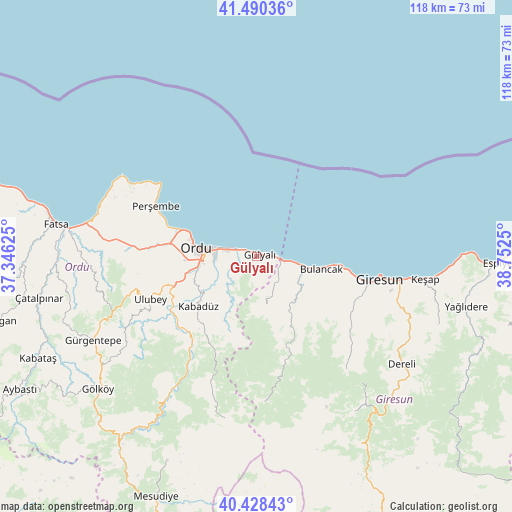
Gülyalı GPS coordinates[2]
40° 57' 41.508" North, 38° 2' 57.732" East
| Map corner | latitude | longitude |
|---|---|---|
| Upper-left | 41.49036°, | 37.34625° |
| Center: | 40.96153°, | 38.04937° |
| Lower-right: | 40.42843°, | 38.7525° |
| Map W x H: | 118.1×118.1 km | = 73.4×73.4mi |
| max Lat: | 42.02683° ⇑11.9% North |
| Gülyalı: | 40.96153° |
| min Lat: | ⇓88.1% South 35.9025° |
| min Long | Gülyalı | max Long |
| 25.90902° | 38.04937° | 44.60099° |
| W 61.9%⇐ | ⇒38.1% E |
Elevation
Elevation of Gülyalı is 123 m = 404 ft, and this is 594.4 m = 1950 ft below average elevation for this country.
| Max E: |
2682 m = 8799 ft | 78.9% |
| Avg. | 717.4 m = 2354 ft | |
| Gülyalı | 123 m = 404 ft | |
Min E: |
0 m = 0 ft | 21.1% |
See also: Turkey elevation on elevation.city.
Geographical zone
Gülyalı is located in North temperate zone (between Tropic of Cancer and the Arctic Circle). Distance of this Northern Tropic circle is 1948.6 km =1210.8 mi to South.| Distance of | km | miles | from Gülyalı |
|---|---|---|---|
| North Pole | 5452.6 | 3388.1 | to North |
| Arctic Circle | 2846.7 | 1768.9 | to North |
| Tropic Cancer | 1948.6 | 1210.8 | to South |
| Equator | 4554.5 | 2830 | to South |


Nearby cities:
15 places around Gülyalı: (largest is in red/bold)
• Altınordu
15 km =9.3 mi,  279°
279°
• Bolaman
39.1 km =24.3 mi, 281°
• Bulancak
15.5 km =9.6 mi,  99°
99°
• Dereli
41.4 km =25.7 mi,  126°
126°
• Giresun
28.8 km =17.9 mi, 99°
• Kabadüz
17.8 km =11.1 mi,  231°
231°
• Keşap
38.4 km =23.9 mi, 98°
• Kovanlık
23.6 km =14.7 mi,  167°
167°
• Ordu
13.5 km =8.4 mi, 277°
• Perşembe
26 km =16.2 mi,  296°
296°
• Piraziz
5.1 km =3.2 mi, 100°
• Piraziz
7.7 km =4.8 mi,  124°
124°
• Ulubey
26.9 km =16.7 mi,  247°
247°
• Uzunisa
17.7 km =11 mi, 252°
• Yavuzkemal
38.4 km =23.9 mi,  140°
140°
Sources, notices
• [Note1] Compared only with cities in Turkey existing in our database
• [Src1] Map data: © OpenStreetMap contributors (CC-BY-SA)
• [Src2] Other city data from geonames.org with taken over terms of usage.
• [Src3] Geographical zone / Annual Mean Temperature by Robert A. Rohde @ Wikipedia
