Torul geodata
Torul (Gümüşhane) is a seat of a second-order administrative division; located in Turkey in Europe/Istanbul (GMT+3) time zone. With population of 4,832 people, there are 736 cities with bigger population in this country. Compared to other cities in Turkey, 78.5% of cities are located further ↓South; 69.6% of cities are located further ←West and 81.9% of cities have lower elevation than Torul. Note1


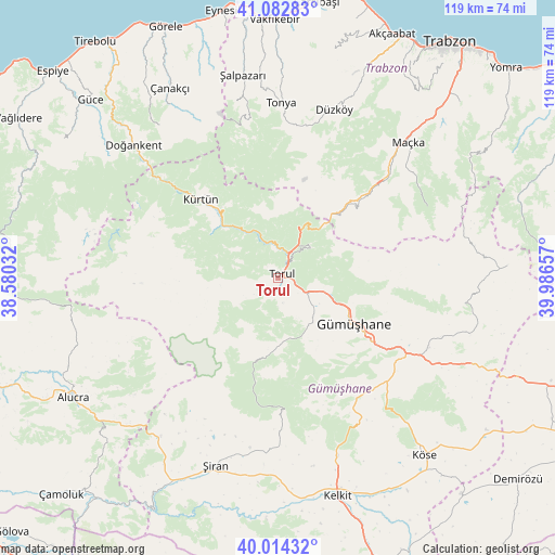
Torul GPS coordinates[2]
40° 33' 2.556" North, 39° 17' 0.384" East
| Map corner | latitude | longitude |
|---|---|---|
| Upper-left | 41.08283°, | 38.58032° |
| Center: | 40.55071°, | 39.28344° |
| Lower-right: | 40.01432°, | 39.98657° |
| Map W x H: | 118.8×118.8 km | = 73.8×73.8mi |
| max Lat: | 42.02683° ⇑21.5% North |
| Torul: | 40.55071° |
| min Lat: | ⇓78.5% South 35.9025° |
| min Long | Torul | max Long |
| 25.90902° | 39.28344° | 44.60099° |
| W 69.6%⇐ | ⇒30.4% E |
Elevation
Elevation of Torul is 1230 m = 4035 ft, and this is 512.6 m = 1682 ft above average elevation for this country.
| Max E: |
2682 m = 8799 ft | 18.1% |
| Torul | 1230 m 4035 ft | |
| Avg. | 717.4 m = 2354 ft | |
Min E: |
0 m = 0 ft | 81.9% |
See also: Turkey elevation on elevation.city.
Geographical zone
Torul is located in North temperate zone (between Tropic of Cancer and the Arctic Circle). Distance of this Northern Tropic circle is 1902.9 km =1182.4 mi to South.| Distance of | km | miles | from Torul |
|---|---|---|---|
| North Pole | 5498.2 | 3416.4 | to North |
| Arctic Circle | 2892.4 | 1797.3 | to North |
| Tropic Cancer | 1902.9 | 1182.4 | to South |
| Equator | 4508.8 | 2801.6 | to South |


Nearby cities:
15 places around Torul: (largest is in red/bold)
• Doğankent
42.1 km =26.2 mi,  312°
312°
• Düzköy
37.7 km =23.4 mi,  17°
17°
• Evren
35.2 km =21.9 mi,  195°
195°
• Eymür
48 km =29.8 mi, 313°
• Gumushkhane
18.8 km =11.7 mi,  122°
122°
• Kale
38.4 km =23.9 mi, 118°
• Kelkit
48.8 km =30.3 mi,  164°
164°
• Kürtün
22.6 km =14 mi,  315°
315°
• Maçka
39.6 km =24.6 mi,  43°
43°
• Tonya
37.1 km =23.1 mi,  0°
0°
• Yağlıdere
20.6 km =12.8 mi,  91°
91°
• Yağmurdere
49 km =30.4 mi, 86°
• Çanakçı
47.2 km =29.3 mi,  328°
328°
• Şalpazarı
43.8 km =27.2 mi,  349°
349°
• Şiran
42.4 km =26.3 mi, 199°
Sources, notices
• [Note1] Compared only with cities in Turkey existing in our database
• [Src1] Map data: © OpenStreetMap contributors (CC-BY-SA)
• [Src2] Other city data from geonames.org with taken over terms of usage.
• [Src3] Geographical zone / Annual Mean Temperature by Robert A. Rohde @ Wikipedia
