Kale geodata
Kale (Gümüşhane) is a seat of a second-order administrative division; located in Turkey in Europe/Istanbul (GMT+3) time zone. In our database, there are 1323 cities with bigger population. Compared to other cities in Turkey, 75.7% of cities are located further ↓South; 72.1% of cities are located further ←West and 87.1% of cities have lower elevation than Kale. Note1


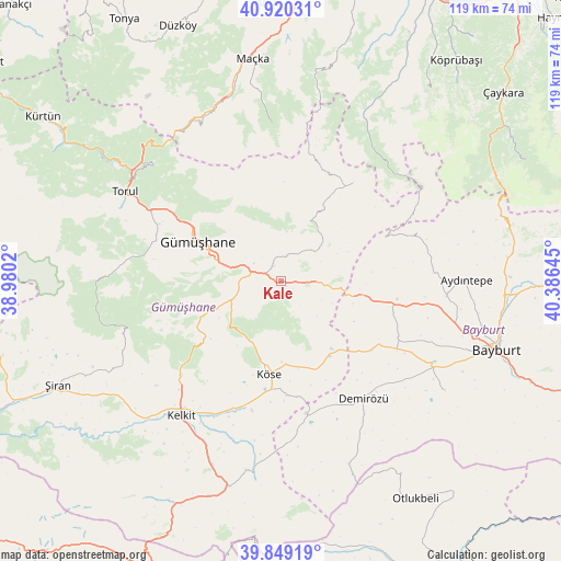
Kale GPS coordinates[2]
40° 23' 12.768" North, 39° 40' 59.952" East
| Map corner | latitude | longitude |
|---|---|---|
| Upper-left | 40.92031°, | 38.9802° |
| Center: | 40.38688°, | 39.68332° |
| Lower-right: | 39.84919°, | 40.38645° |
| Map W x H: | 119.1×119.1 km | = 74×74mi |
| max Lat: | 42.02683° ⇑24.3% North |
| Kale: | 40.38688° |
| min Lat: | ⇓75.7% South 35.9025° |
| min Long | Kale | max Long |
| 25.90902° | 39.68332° | 44.60099° |
| W 72.1%⇐ | ⇒27.9% E |
Elevation
Elevation of Kale is 1368 m = 4488 ft, and this is 650.6 m = 2135 ft above average elevation for this country.
| Max E: |
2682 m = 8799 ft | 12.9% |
| Kale | 1368 m 4488 ft | |
| Avg. | 717.4 m = 2354 ft | |
Min E: |
0 m = 0 ft | 87.1% |
See also: Turkey elevation on elevation.city.
Geographical zone
Kale is located in North temperate zone (between Tropic of Cancer and the Arctic Circle). Distance of this Northern Tropic circle is 1884.7 km =1171.1 mi to South.| Distance of | km | miles | from Kale |
|---|---|---|---|
| North Pole | 5516.5 | 3427.8 | to North |
| Arctic Circle | 2910.6 | 1808.6 | to North |
| Tropic Cancer | 1884.7 | 1171.1 | to South |
| Equator | 4490.6 | 2790.3 | to South |


Nearby cities:
15 places around Kale: (largest is in red/bold)
• Aydıntepe
38.9 km =24.2 mi,  90°
90°
• Bayburt
48 km =29.8 mi,  107°
107°
• Dağbaşı
42.5 km =26.4 mi,  26°
26°
• Esiroğlu
54.1 km =33.6 mi,  0°
0°
• Evren
45.9 km =28.5 mi,  249°
249°
• Gumushkhane
19.7 km =12.2 mi,  294°
294°
• Kelkit
35.8 km =22.2 mi,  216°
216°
• Köse
20.3 km =12.6 mi,  188°
188°
• Maçka
47.6 km =29.6 mi,  351°
351°
• Otlukbeli
54.4 km =33.8 mi,  148°
148°
• Pulur
30.8 km =19.1 mi,  144°
144°
• Torul
38.4 km =23.9 mi,  298°
298°
• Yağlıdere
21.9 km =13.6 mi,  323°
323°
• Yağmurdere
25.8 km =16 mi,  35°
35°
• Şiran
52.7 km =32.7 mi, 245°
Sources, notices
• [Note1] Compared only with cities in Turkey existing in our database
• [Src1] Map data: © OpenStreetMap contributors (CC-BY-SA)
• [Src2] Other city data from geonames.org with taken over terms of usage.
• [Src3] Geographical zone / Annual Mean Temperature by Robert A. Rohde @ Wikipedia
