Kelkit geodata
Kelkit (Gümüşhane) is a seat of a second-order administrative division; located in Turkey in Europe/Istanbul (GMT+3) time zone. With population of 23,870 people, there are 296 cities with bigger population in this country. Compared to other cities in Turkey, 71.2% of cities are located further ↓South; 70.8% of cities are located further ←West and 88.5% of cities have lower elevation than Kelkit. Note1


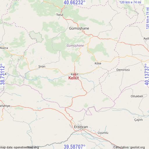
Kelkit GPS coordinates[2]
40° 7' 36.552" North, 39° 26' 3.264" East
| Map corner | latitude | longitude |
|---|---|---|
| Upper-left | 40.66232°, | 38.73112° |
| Center: | 40.12682°, | 39.43424° |
| Lower-right: | 39.58707°, | 40.13737° |
| Map W x H: | 119.6×119.6 km | = 74.3×74.3mi |
| max Lat: | 42.02683° ⇑28.8% North |
| Kelkit: | 40.12682° |
| min Lat: | ⇓71.2% South 35.9025° |
| min Long | Kelkit | max Long |
| 25.90902° | 39.43424° | 44.60099° |
| W 70.8%⇐ | ⇒29.2% E |
Elevation
Elevation of Kelkit is 1414 m = 4639 ft, and this is 696.6 m = 2285 ft above average elevation for this country.
| Max E: |
2682 m = 8799 ft | 11.5% |
| Kelkit | 1414 m 4639 ft | |
| Avg. | 717.4 m = 2354 ft | |
Min E: |
0 m = 0 ft | 88.5% |
See also: Turkey elevation on elevation.city.
Geographical zone
Kelkit is located in North temperate zone (between Tropic of Cancer and the Arctic Circle). Distance of this Northern Tropic circle is 1855.8 km =1153.1 mi to South.| Distance of | km | miles | from Kelkit |
|---|---|---|---|
| North Pole | 5545.4 | 3445.8 | to North |
| Arctic Circle | 2939.5 | 1826.5 | to North |
| Tropic Cancer | 1855.8 | 1153.1 | to South |
| Equator | 4461.7 | 2772.4 | to South |


Nearby cities:
15 places around Kelkit: (largest is in red/bold)
• Başköy
44.8 km =27.8 mi,  129°
129°
• Cimin
51.6 km =32.1 mi,  153°
153°
• Doğanbeyli
58.8 km =36.5 mi,  215°
215°
• Erzincan
43.4 km =27 mi,  173°
173°
• Evren
25.6 km =15.9 mi,  300°
300°
• Gumushkhane
37.2 km =23.1 mi,  4°
4°
• Kale
35.8 km =22.2 mi,  36°
36°
• Köse
20.1 km =12.5 mi,  63°
63°
• Otlukbeli
52.7 km =32.7 mi,  109°
109°
• Pulur
39.1 km =24.3 mi,  84°
84°
• Torul
48.8 km =30.3 mi,  344°
344°
• Yağlıdere
47.1 km =29.3 mi,  9°
9°
• Çatalarmut
37.4 km =23.2 mi,  195°
195°
• Çatalçam
52.7 km =32.7 mi,  251°
251°
• Şiran
27.8 km =17.3 mi,  284°
284°
Sources, notices
• [Note1] Compared only with cities in Turkey existing in our database
• [Src1] Map data: © OpenStreetMap contributors (CC-BY-SA)
• [Src2] Other city data from geonames.org with taken over terms of usage.
• [Src3] Geographical zone / Annual Mean Temperature by Robert A. Rohde @ Wikipedia
